|
W"e're climbing Rainier later this month. Are you interested?" chattered Matt over the phone. The wild idea is to climb Washington's highest peak from sea level, which is one of the lower 48s biggest and baddest. It's been an idea of his knocking around in the back of his mind for the past several years. With my flexible work schedule, I give it brief thought and send out a text on my new phone.
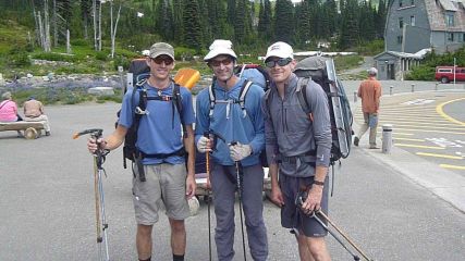
The day quickly looms closer, and I load up my pack the night before. Matt picks me up and we head north to Bozeman, MT. We pass several places that stir my mind from my Continental Divide Thru-Hike five years ago. There's the trail town of Rawlins, NM, and we pass Mineral X Road, the two track dirt road that pierces the heart of the Great Divide Basin. We arrive in Bozeman, MT and meet Braden, a childhood friend of Matt's, and one of the few that can keep up with his catamount cruiser-like pace.
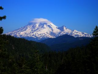
 Mt. Rainier's Paradise Jackson Visitor Center |
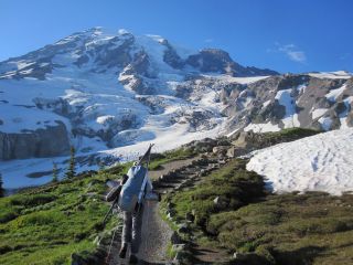 |
Paradise Visitor's Center, Rainier National Park, WA
 Weather forecast |
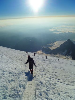
We begin the climb on a paved trail, busy with tourists speaking in their native tongue from around the world. The trail turns to dirt, and crowds thin as fingers of snow sprawl across the trail. I struggle to keep up with the two speed demons as the trees thin and we reach timberline. The Muir Snowfield looms ever closer, and Pebble Creek dives under the snow. The climb to Camp Muir takes seemingly forever as we near the halfway mark of the 4,500 foot climb to the mountaineering camp.
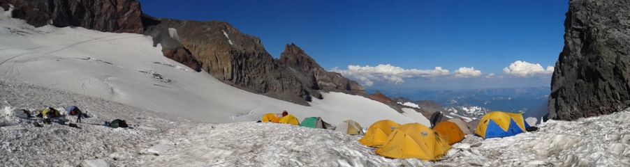 Camp Muir, 10,080 feet MSL |
July 27 Summit Day, Muir Camp, Mount Rainier National Park, WA
 |
 |
 |
We stay with college friend of Braden that night in the outskirts of Seattle, and Becca shares her stories as a high school teacher and making us an amazing dinner to fuel us through the next adventure. We head on the next day to a friend of Matt's and ready ourselves for round two. Mike gets a day off of work from the hospital, and our party of three has grown by one person. After celebrating the 77th birthday of a neighborhood pub briefly, we're back at Mike's.
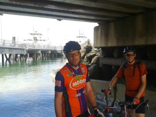
It's 29th day of July, and a blanket of clouds shroud the sky. Braden and Matt take a couple of deep breaths as the idea that's been rolling around in the back of their heads now comes to fruition. As early afternoon arrives, the two bikes go back on the car, and the four of us drive down to the Steilacoom ferry dock and stare at the small boat ramp that lies under the railroad tracks. They pull their bikes down off the car, lube the chains, and we head back to the water.
 Only 15,800 feet of climbing and 85 miles to go |
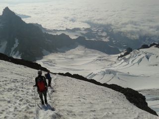
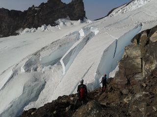
We get our permits again and throw our packs on. Mine now includes skis and boots, and Braden and Matt's climbing gear, food, and cooking implements. Mike helps me as I struggle to don the overweight frameless pack. We limp our way up to the Visitor Center and I continue to down as much water as I can. I fill up my quart bottle, and we start the 4,800 foot climb. The wispy clouds that were once above us now lie in our faces as fog. We soon reach the toe of the Muir Snowfield at Pebble Creek and gaze towards Muir Camp, towering on a distant ridge. The climb seems agonizing as 40 plus pounds of stuff slump down on my shoulders and hips. We climb onto the snowfield and develop a rhythm as the steep trail is replaced by endless snow. Hours slip by as we pass waterfalls gushing from the glacier's bowels ringing the surrounding terrain. The sky grows dark as we death march to Muir Camp. After four hours of slogging, we limp our way to an old tent site and I throw up my shelter. As I start to set up the stove, Mike returns from setting his sleeping bag in the crowded hut. "Hey, how's it going" blurts a climber to Mike. The two look at each other under dark skies and pause. "Is that you Braden?" mumbles Mike? He responds with a surprised look full of expression. Despite Mike and I driving the 80 miles from Puget Sound to the Visitor's Center, Matt and Braden have still managed to reach us less than a half hour after Mike and I arrived. They don't appear to be tired or ready for rest. Our goal of having a warm meal and water ready for them was about successful as the Feds having a balanced budget. The pace picks up as we busily race around camp melting water, cooking food, donning helmets and harnesses, changing out of wet gear, and eating.
We send off Braden and Matt onto the second leg of their epic feat a little after 11pm and watch their two headlamps disappear into the darkness. The rustling sound of tents opening and footsteps crunching in the firm snow surround me as I zip up my shelter and go to bed.
Sometime after 6am I hear the crunch of footsteps nearing my tent. I peek under the shelter and see Matt and Braden with tired, weathered smiles that reach from ear to ear. The two wobble toward the hut for some well-deserved rest and get another couple hours of rest.
As I sit here in the backseat typing up this trip report somewhere near Coeur d'Alene, Idaho, Braden spits out some statistics:
Matt & Braden's Sea to Summit climb:
•The climb from Steilacoom, WA (0ft MSL) to the summit of Mt. Rainier (14,411ft): 12hrs 44mins 30secs.
•Total vertical climbed: 15,800
•77.3mi of biking
•7mi of climbing
•9,000ft of downclimbing back to the parking lot.