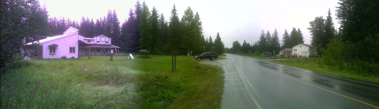
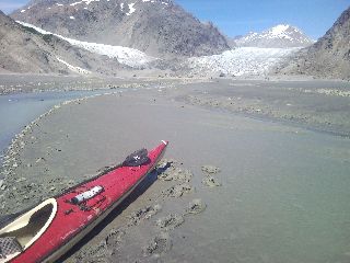
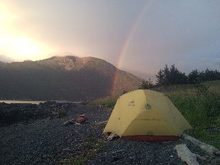
I take my third zero day, or day off, this summer—and it feels good. I'm not sore, nothing hurts, but it's nice to do something besides swing the arms and torso around. A few of us head across the bridge from Douglas Island to Juneau proper to tour the town and hang around for the nightlife. On the final day, I decide to resupply at Costco again. Where else am I going to find a four pound bag of M&Ms, GORP, or cereal, five pounds of carrots, or a box of sixty candy/energy bars? The quarter gallon of hummus sounds really good too. As I wait for a ride back to Douglas Island, I decide to exercise the brain a little. I count the calories from the oversized boxes of stuff I purchased, and come up with 94,160 calories—and I still have a few items from the last Costco run in town almost two months ago. Altogether, I have over 100,000 calories stuffed in the three bear bags, a grocery sack, and a small backpack. As I ready myself for departure, five come down to the shore and help me carry the over one hundred thousand calories worth of food—probably seventy pounds worth—almost three gallons of water, and thirty six pounds of gear across the street and down to the shore. I don't really know where I'm going to resupply next: Gustavus, Juneau, Haines, Skagway? The boat easily inhales everything I throw at it.
 The Mendenhall Glacier |
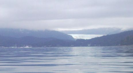
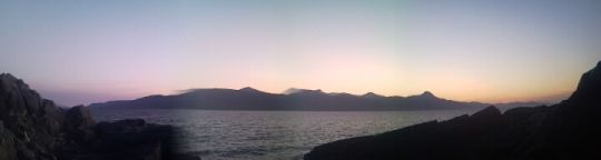
I tune to the weather on my VHF radio for the several miles of crossing the Favorite and Saginaw Channels, and Lynn Canal. The report blurts out the record highs for the Southeastern Alaska towns—unusual, but so is the weather. The record highs of upper 70s for Juneau, upper 80s for Haines, and low 90s for Skagway may be broken come August 3rd and 4th as abundant sun and record heat are expected to bake the area. Winds blowing from the south have also been very rare this summer. They're usually associated with unstable weather and low pressure systems passing through. This is also the only time I've ever paddled south for over ten miles. My dreams of paddling with a south wind at my back disappear as I pass Shelter Island, and eventually slide around the lighthouse at Point Retreat. The usual northwest winds subside this morning to a quiet whisper, and the southerlies roar to life.
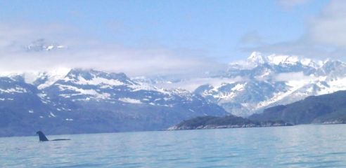
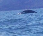 Humpback whale |
 |
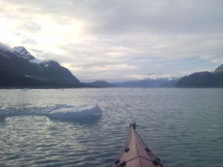
There's a good breeze blowing as I leave my exposed camp behind. The tides are in neap, meaning minimal, with the half moon brightly agaze directly above as the sun rises forty five degrees away. In a week, the seas will rise and fall faster and farther as a new moon and sun closely together sprout spring tides. I cross the two thousand foot deep waters of Lynn Canal and skirt the edge of the Endicott River Wilderness on my way to the Couverden Islands. Several mist plumes erupt as humpbacks feed nearby. The route that saves several miles of paddling, and protects me from the wind and chop of Lynn Canal can dry at low tide—and I don't want to get stuck out here. The waters continue to recede as the sun and moon draw them thousands of miles out to sea. I squeeze through a narrow opening into the lagoon surrounded by the pencil thin Couverden Islands.
 |
The waves drain away to nothing, and dead calm is in the air. The temperatures seem to double instantly. I feel like an oven door has been opened and placed on the bow of my boat. I eye the shade behind an island to peel off layers while I traverse the lagoon. I spot ripples on the water that grow larger as I near, and a blast of wind howls through my hair and chills me like walking into a refrigerator. Ahead lies a menacing wall of land that seemingly dead ends. There are tall pilings growing out of the ground like a dead forest. Is this a channel through here, I ask myself. A narrow twenty or so foot opening suddenly appears sneaking out from behind the wall of tidelands in front of me. I sneak my way through the channel, feeling like I'm paddling along a flooded street after a damaging rainstorm.
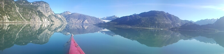
 Navigating Swanson Channel |
 |
The seas noisily crash against the nearby rocks all night long as a string of three small floating cities in a row slowly steam by. The cruise ships have been a common sight as they head back from Glacier Bay. My stolid mind is not ready for more headwinds and chop, but I manage to hit the water before 6am with four foot waves pounding me as I head away from shore. The weather forecast calls for fifteen knots today (a headwind, of course) with gusts to thirty five this morning. Great, I guess I'll be blown back to Juneau by the end of the day. The sky is overcast, keeping the relentless hot sun from frying me, although the winds have done a good job of that too. The incredulously rough seas grow steadily until just before noon as I pass over a dozen fishing boats trolling the waters. The pace is slow as vicious whitecaps bounce and break under my bow between Porpoise and Pleasant Islands. There is another small craft advisory in effect this evening as I skirt around to the north side of Pleasant Island. A family of sea otters inquisitively stare at me before disappearing toward the ocean depths. A narrow ledge above the high water line on a small point is off to my left, and my day ends with the high peaks of Glacier Bay staring directly at me. I enjoyed another high salt diet forced into me as I involuntary inhaled saltwater pounding my face. An olympic-sized swimming pool sloshes around in my cockpit as water oozes through my sprayskirt worn with swiss cheese sized holes. The night sky fills with clouds as I sleep under the stars again. At two in the morning a light mist soaks my face and wakes me. I throw up the tent fly and drift back to sleep.
Glacier Bay National Park
|
|
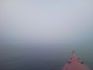
An impenetrable blanket of fog shrouds the calm seas today as I blindly cross
Icy Passage and slip past the long dock from Gustavus appearing from nowhere.
 |
Gustavus, AK
There's an old rickety scale sitting outside, and I throw all my gear on and see
what she reads: 36 pounds, which excludes the repair kit, spare paddle, and
bilge pump still sitting in the boat, and the drysuit flung over a line drying
out. We head over to her place and enjoy halibut for dinner with a couple of her
friends. Gustavus is a town of several hundred, most of which are Park Service
employees. It's a mile from the water, making it a not-so-easy place to explore
or resupply from the water.
 Downtown Gustavus |
I arrive back in the Park on this sixth of August as the sky spits out bits of drizzle. I attend the next video orientation required for my backcountry permit mid afternoon, and get back on the water as low tide approaches. The water's over eight feet too low to make a sneak around the east side of Lester Island, so I head southwest, straight into the steady headwind heaving four foot chop onto my boat. My relatively dry cockpit—and everything in it including me—is now sloshing around in a puddle growing larger with every towering wave. I pass close to shore avoiding the tide rips churning around to my left as water rushes in to fill Glacier Bay through the tight confines of Sitakaday Narrows. The funny water is teeming with boils and wakes piling in from every direction this evening. As hard as I try to avoid the boiling, bubbling concoction, it's everywhere. The seas have calmed some this evening, with the roar of the several foot high rips surrounding me like an attacking army. I power through and ride the rough waters to the calmer seas just ahead. There's a large boil of smooth water surrounded by small, choppy pyramid shaped waves as I bash through on my way to Netland Island.
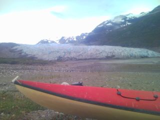
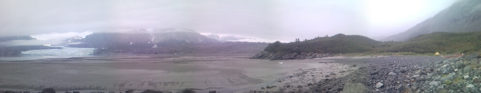
I didn't get into camp until well after nine last night, so I sleep in this morning. I tear down my tent, used for the first time in over a week, and glance out at Whidbey Passage, and the small tide rips stretching across the bay from the point I'm camped near. a thick shroud of fog drops in from the heavens and coats me in a fine mist. There are no old growth forests around here, no thick canopy, no endless sea of green. Thick alders guard the forest entrance on land that was buried in ice two hundred years ago. In a few days, there will be walls of ice towering above me like city skyscrapers. The deafening roar of glaciers calving into the sea will ring in my ears. Harbor seals napping on icebergs will stare at me with their beady eyes.
The humpback whales and sea otters have slowly disappeared the last two days as I mosey my way into the upper reaches of Glacier Bay. I make a sharp left turn into Reid Inlet to a towering cathedral of ice getting closer with each paddle stroke.
 Reid Glacier |
I leave the bottomless mud of Reid Inlet and head out to Glacier Bay.
 Reid Glacier |
 Lamplugh Glacier |
 Johns Hopkins Glacier |
 The Johns Hopkins Glacier looming 250 feet above |
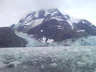 Gilman & Johns Hopkins Glacier |
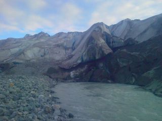
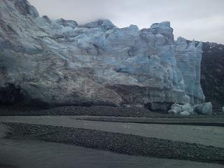
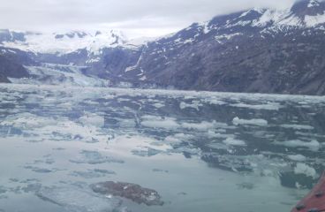
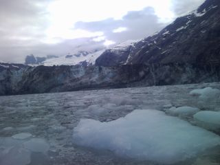
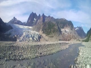
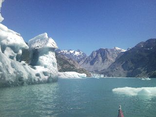
There's a two mile wide block of dirty ice that lies in front of me. On my way to the Johns Hopkins yesterday, I glanced at it thinking it might be a ridge of land. The Grand Pacific Glacier is around one hundred feet high, piled thick with rocks and dirt constantly plunging off its edge. As I approach closer, Margerie Glacier looms to my left. The source of the occasional crash I've heard over the last hour or so, the mile wide face over two hundred feet high (and 50-100 below the waterline) jets into the sea. I park myself away from the edge and see what it has to offer. A Coast Guard vessel is nearby, along with a gigantic private yacht. The Marge moves about half as much as Johns Hopkins, about six to eight feet a day. There's an occasional crash and boom, and after an hour, I head on, following along the filthy toe of the Grand Pacific Glacier. A frequent crackle of rockfall is the only quiet roar coming from the two mile wide monster. It's a little after noon as I hop out of my boat and climb a small outwash moraine on the east end of the Grand Pacific. There's the fast moving silty creek churning its way alongside the glacier's toe, and lots of mud; mud carried here from the high peaks over the eons. I turn around dumbfounded with what I'm surrounded by, and decide to push no more today. I find a nearby beach and set up camp.
 Margerie and Grand Pacific Glaciers |
I leave camp well before 6am and just beat the receding waters. Less than fifteen minutes later, the shallow mud flat adjacent to camp is now exposed with bottomless suck mud. Carrying the boat over quicksand as slick as a slip'n'slide wouldn't have been fun. I turn around a few times later in the day as I leave Tarr Inlet, and gaze at the Grand Pacific Glacier that seems to snake up to the heavens forever.
 |
 Orca combing the waters |
"Congratulations, whichever fork you choose to complete the Inside Passage. Take a picture, take a pee, never forget this moment and have a safe journey home." —Kayaking the Inside Passage |
Yesterday I spotted a couple paddlers camped off along the distant shore, and a double kayak following along the opposite shoreline a ways off. That's it for kayakers, which I find quite surprising. This is a hotspot for the activity, but mid August might be considered late season around here. I pass a few icebergs as I paddle up Muir Inlet under warm, blue skies.
 Mountain Goat and Muir Glacier |
The earth inhales and exhales every six hours with one enormous, slow breath as the seas rise and fall. A new world comes to life in the intertidal zone as an infinite number of creatures and plants make a living out here. Across Muir Inlet in the narrow confines at McBride Glacier, the crash of calving ice roars into the open and rings along the bare rock walls that rise to impossible heights all around me. I make a left turn around White Thunder Ridge to the dry leeward expanse of bare rock and waterfalls dropping down from the heavens. I fill up my waterbags at a spring oozing out of the rock and get a blank stare from a nearby mountain goat. A wide smile stretches across my face as I near the last turn to Muir Glacier. This is it, the last hurrah in Glacier Bay National Park. I could paddle out to a pick up location tomorrow and then get whisked away by plane to Seattle, but I have better ways to spend many hundreds of dollars—this adventure isn't over yet.
 |
 The Muir Glacier |
 |
 Riggs Glacier |
I'm up early to catch high tide before the bottomless mudflats surround my camp. A couple miles later, I squeeze through the narrow iceberg choked entrance past the terminal moraine, opening up into a half mile wide inlet as the infrequent crash of ice echoes along the steep walls thrusting into the sky. Squirming through the iceberg choked waters, I stare at the full grandeur of the McBride Glacier. As soon as I stop, a hundred foot high column of brown ice crashes into the frigid waters. Water shoots skyward like a geyser, and a surge wave crashes against the shore and heaves towards me like a freight train. By the time it reaches me, it's like an open ocean swell noisily slipping underneath my boat as the bergy ice bits chatter and crack as they collide with each other. Large distant bergs pull sudden U-turns as their bases melt making them top heavy.
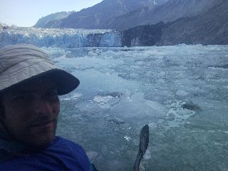 McBride Glacier |
 |
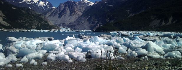 The iceberg graveyard |
McBride is probably the most active tidewater glacier in the park. It towers over 200 feet high, while another 300 feet lie below water. It's a half mile wide, twelve miles long, and slides into the sea at a rate of over a mile a year—more than any other glacier in the Park. It's also disappearing faster than any other body of ice. It will likely be nothing more than another wall of white terminating far above the sea in the not so distant future.
The air last night was full of the snap, crackle, and pop of dying icebergs as they flowed out into Muir Inlet. The crash of a calving berg, and loud smack of a large swath of ice barreling down on another firmly anchored to the seafloor echoed onto the moraine I slept on without my tent. The ever changing iceberg graveyard that sits in front of me ceased to entertain. These sights will disappear one of these years as the last three tidewater glaciers in the Park slowly die. I had the entire McBride Glacier and Inlet to myself—I had the entire fifty mile long Muir Inlet to myself. For the second time this summer (the other being yesterday), I saw no one, no boats, no motor noise. I thought I might be paddling and sharing the experience here in the Park with others, which is usually teeming with kayakers, but this time of the year I guess boats are few and far between. I depart from the cold confines of this magical place and follow the busy highway of ice streaming out the inlet and around the corner just after slack tide. It's been almost twenty four hours since I arrived here, and my days of glacier exploration are done. This was the last hurrah, there are no more rivers of ice terminating into the sea as I exit the Park over the next few days. I reflect on the last ten days I've been in Glacier Bay, and it's been an experience that has nearly moved me to tears—so alive, so overwhelming, it seems to stir every passion as I think back. I pass my last small iceberg near Adams Inlet as Muir Inlet widens and straightens, and the winds howl back to life.
There is mist in the air, and fog growing thicker as the morning yawns to life. It looks like it's back to reality with the weather. I've used my tent for the first time in a week, and I need to think about where my rain gloves and cold weather skull cap are. A small rockslide plunges into the depths off in the distance as I tie up to some bull kelp and take a nap in the rain. A good half hour later, twenty knot winds roar across Beartrack Cove as I struggle to reach the Beardslee Islands. The winds subside as I duck into the protected confines of the shallow waters in the dense fog. I take compass bearings as nearby islands come and go like ghosts. Gone are the rock and ice plunging down from from the heavens. The sounds of wildlife spring back to life, until the dull scream of rain drowns everything else out. These islands will not be islands for long. As the glaciers melt, and their great weight from the land disappears, isostatic uplift heaves the ground upward over an inch a year. The rain and dense fog today gave the islands and steep shores a magical quality. I set up camp on a narrow spit in the Beardslee Islands as the sonorous sounds of wildlife ring in the still, rainy air.
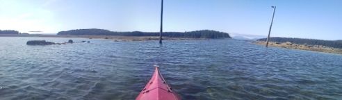
I head along the narrow channel toward Lester Island as the tides slowly rise. Bartlett Cove, and the Park's dock, lie through a narrow slot only passable when tides reach above ten feet. I glance around the corner to exposed rock covered in bubble kelp (rockweed).
 |
I leave the dock mid afternoon and head out towards Icy Strait. A humpback surprises me as it surfaces less than twenty yards away. As I reach Gustavus Point, I spot a black bear near the water combing the shore for clams and grubs. An hour later, a sea lion startles me as it surfaces for air and darts back into the water right behind me. The headwinds are blowing at me again as I pick a place to camp on the south side of Pleasant Island.
Today was a short day. I was on the water after 9am and as I reached Porpoise Island less than ten miles later, I was beat. I never get enough sleep during town stops, and the east wind is killing me—and I have over ten days to get to Skagway. There is partial clearing tonight, and I glance at the Big Dipper pointing brightly at the North Star—Alaska's State Flag.
As morning lets out a big yawn, the winds pick up, and the waves soon follow. But something's different. The wind isn't blasting me in the face, I don't even feel it, but I know it's there. It's at my back. Today was one of those extremely rare, I can count-the-number-on-one-hand days where I was pushed by winds. The tailwind gradually builds, and the chop soon follows. I buzz past several Sitka black tail deer as I briefly surf an odd wave here and there past the Couverden Islands, which I avoid this time. I don't feel like paddling in still air under bright sun through the calm, protected islands. It was calm and still earlier today, and my watch was reading 87°. There's a dark object on the beach starting to slowly move as a sow and her two cubs follow the shore while she looks for tasty grubs. I cross the twenty one hundred foot deep waters of Lynn Canal at over three knots as the tailwind continues. One of my waterbags has developed a pinhole leak, and I'm running short. I head toward Funter Bay and spot what might be a creek in the distance. I reach the narrow beach, call it a day, and set up camp. Heading over to the creek, the rustle of leaves. A sow stands on her hind legs as her cub runs behind her. There's dead fish parts shredded all over the rocky beach, and
 |
The waters are busy with fishing boats everywhere. Some are commercial, trawling nets behind, but most are from Juneau on this drizzly Sunday. I follow close to shore as a large stellar sea lion curiously follows me from a distance. The sea erupts with bubbles rising to the surface nearby as a humpback rises to bubble-net feed. A steady stream of boats round Point Retreat and follow Saginaw Channel on their way back to the Borough of Juneau. The sky is busy with the buzz of aircraft coming from every direction. What has taken me three or four days to paddle through a wild myriad of conditions takes a plane from Gustavus less than ten minutes—although they probably don't see anything other than the dull white of cloud tops on a day like today. I follow Shelter Island and squeeze through North Pass as large tide rips throw me around. The Pass is busy with tour boats and private vessels gathered around a feeding humpback. There's a small craft advisory tomorrow as a front passes through, and I try to decide where I'm going to wait it out. Shelter Island is a bit cliffy, Gull Island is nearby, and the Eagle River, with Herbert Glacier staring at me from high above is listed in my guidebook. With a freshening south wind blowing, I'll continue on toward Benjamin Island. There's a narrow tombolo jetting off from the end of the island, and I reach the protected waters and take a look around. There's a firepit on the exposed bar, and in the trees, there's a soft, flat spot nestled in the pine duff. What a change after setting up camp on rocks for most of Alaska. I set up camp as winds howl through the treetops above, and the unsettled sky spits out rain. With my ultimate destination so close, today was probably the last twenty plus mile day.
My plan today is... nothing. The winds barely purr as light precipitation pelts the rainforest.
 Today's Vitamin-rich tannin waters |
Yesterday was rather uneventful, other than what I saw reaching the far end of Berners Bay. Water was wildly splashing from a half dozen different places just ahead as porpoises raced around like a game of tag. This morning I wait for the moderate rains to stop pelting my tent before I break camp at 8am here near Sherman Point. The winds purr from the north as low clouds tightly hug the steep mountains that surround me. I take an early afternoon break at the base of a near vertical creek cascading from the frozen icefields that lie above. A noisy red squirrel clinging to nearby spruce tree chatters loudly to announce its presence. The cold, penetrating fog lifts, and the winds dull to a gentle purr. I fill up my two plus gallons of waterbags and dine on some snacks. The strong winds Lynn Canal is famous for (along with every other inlet, canal, pass, passage, narrows, and strait I've been in) take a nap. The sea calms to a surface as smooth as a baby's behind.
 A rare occurrence—Calm winds in the far reaches of Lynn Canal |
I'm suddenly awakened by the whoosh of a pair of humpbacks twenty yards off the water's edge. I briefly ponder the idea of getting up, but with two days left, forget it. As ten o'clock rolls around, I take my boat down to within several feet of the water and return for some dry cereal for breakfast. I pack up the last of my gear, and load the boat as water nips at the bow. The whales have disappeared today, and the winds are still light, other than a gentle tailwind this afternoon. I reach Kalgaya Point this afternoon with Haines just around the corner.
 |
Haines, AK
It's another big day today—five miles. I reach the large cruise ship docks
standing high above, and beach the boat on the sandy shore at low tide. I haul
my kayak and gear across the street to an outfitters parking lot and meet Joey
at the nearby hardware store. I help him load materials for the home he's
helping his mom build, and we head to Jen's place near Mud Bay.
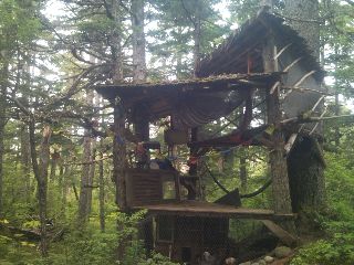 The treehouse |
 Looking towards Skagway from Mt. Riley |
The noisy pitter patter of heavy rain drowns out the twitter of waking birds this morning. I sleep in after last night's fazed sleep and soon reawake to patches of blue sky peeking through the trees. I say my goodbyes, Dan shows me the route a friend of his kayaked along Quebec's Labrador Coast, and I work my way back to the boat. Bright sun blazes above as I push off and paddle to the nearby marina. I fill up my waterbags as sweat pours down my face. I can't paddle in this, wearing only a polypropylene top. I find a park bench and furiously type away to catch up on these journals. I make phone calls, send and receive emails, and soon have a half dozen people to contact when I reach Skagway tomorrow. I hop in my boat and head out of the marina. There's a garden hose nearby, and I head over to fill up a waterbag. "So where are you headed?" blurts out a sailor just finished filleting fish. I tell my story, share some experiences along the way, and get ready to head on for my last night of camping nearby. "Do you want to sleep on our boat? I have some extra salmon?" Spend my last night on a sailboat? Enjoy fresh fish (the thought of eating the store bought salmon pouch around here kind of makes me sick). I give it a half-second of thought, and John and Sidney give me a tour of their boat. What an awesome way to end this trek. I've slept in quite a few cool places, including a cold night on a park bench, and now I find myself cooking up some salmon on a sailboat. I don't really know what to say other than, wow. This afternoon I just gave away a few beer tokens I earned the previous night, and I don't need to go anywhere.
I glance over the Marine Atlas on their boat, looking at some of the charts along my route. I page through to Griffin Passage in central BC, the uncharted narrow channel I followed through teeming with tidal rapids. I look at Grenville Channel, barely a half mile wide in places, where the BC Ferry makes regular runs up and down the narrow confines. I stare at Cape Caution north of Vancouver Island, where I spent four days exposed to open ocean and large swells hammering the rocky coast. As the last whispers of twilight sink below the horizon.
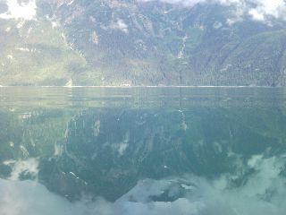
It's less than twenty miles to Skagway today (three hundred sixty by road), so I take a detour into Taiyasanka Harbor to the mouth of the Ferebee River. I inch my way to the entrance where the waters churn and gush as the ebbing sea squeezes through the narrow entrance. A sow and its cub waddle along the opposite shore a half mile away as I reach the mud flats rapidly exposing themselves as low tide approaches. I turn around and head out at slack tide and work my way north along the last stretch of Inside Passage. The shoreline is steep, and the mountains plunge into Lynn Canal. The strong winds that usually funnel their way through the narrow canal, along with its dangerous shearing chop is absent today. I can almost see my reflection in the calm waters as early afternoon arrives. The stern of a large cruise ship parked at the dock looms ever larger as I approach the end of of my voyage.
 My last goodbyes to Big Red as she's carted off to her new home in the Yukon—sold after four days in town |
Skagway, AK
I walk the short distance into town and explore the several blocks near the
water. The place is bustling with tourists—and almost two dozen jewelry
stores—from the three cruise ships docked today. I head to the Red Onion for
some dinner with Janilyn's family and stay in their tiny 'cottage' in their
backyard.
After a few days in town, I'm restless. I hike up to Upper Dewey Lake for the unofficial, Labor Day weekend 'music festival', complete with adult beverages donated by a local brewery and flown in by helicopter.
 The beer run via airlift |
Today is Labor Day, and after the steep twenty two hundred foot descent through thick mud from yesterday's all day rain, I'm ready for more. As 4pm approaches, I hitch a ride to Dyea Campground to start the next adventure.
Chilkoot Trail - Dyea, AK
After almost a week in town, my incessant desire to hike the Chilkoot Trail is
about to become a reality. I first heard about it in the
ALDHA-East Membership Directory in 1997 after my Appalachian Trail
thru-hike. I looked up the long distance and famous trails listing in the back
of the book and paged through to find CT.
One Ton of Gear - Hiking the Chilkoot Trail in 1898: What would you bring? The Canadian government, the North West Mounted Police—now the Royal Canadian Mounted Police—required a year's supply of goods to every stampeder crossing the border. Moving the pile of goods forward was a problem. Stampeders who carried their own goods had the choice of carrying more weight or walking more miles. A light pack of 50 pounds meant more trips. A heavy pack of 80 pounds meant fewer trips, but a heavy burden and slow pace. Every mile walked with a load meant another mile back empty. Some stampeders walked nearly 1000 miles to carry their supplies the 33 miles from Dyea to Lake Bennett. Supplies for one man for one year - Recommended by the Northern Pacific railroad company in the Chicago Record's Book for Gold Seekers, 1897 150 lbs. bacon 400 lbs. flour 25 lbs. rolled oats 125 lbs. beans 10 lbs. tea 10 lbs. coffee 25 lbs. sugar 25 lbs. dried potatoes 2 lbs. dried onions 15 lbs. salt 1 lb. pepper 75 lbs. dried fruits 8 lbs. baking powder 2 lbs. soda 1/2 lb. evaporated vinegar 12 oz. compressed soup 1 can mustard 1 tin matches (for four men) Stove for four men Gold pan for each Set granite buckets Large bucket Knife, fork, spoon, cup, and plate Frying pan Coffee and teapot Scythe stone Two picks and one shovel One whipsaw Pack strap Two axes for four men and one extra handle Six 8 inch files and two taper files for the party Draw knife, brace and bits, jack plane, and hammer for party 200 feet three-eights-inch rope 8 lbs. of pitch and 5 lbs. of oakum for four men Nails, five lbs. each of 6,8,10 and 12 penny, for four men Tent, 10 x 12 feet for four men Canvas for wrapping Two oil blankets to each boat 5 yards of mosquito netting for each man 3 suits of heavy underwear 1 heavy mackinaw coat 2 pairs heavy machinaw trousers 1 heavy rubber-lined coat 1 dozen heavy wool socks 1/2 dozen heavy wool mittens 2 heavy overshirts 2 pair heavy snagproof rubber boots 2 pair shoes 4 pairs blankets (for two men) 4 towels 2 pair overalls 1 suit oil clothing Several changes of summer clothing Small assortment of medicines —NPS |
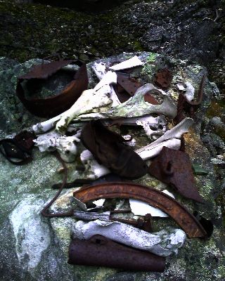
I follow a side trail to the old townsite of Canyon City under crystal clear skies, looking for remnants of the city that once boasted over two dozen businesses and fifteen hundred people, . There's a few scattered pieces of old stoves, broken ceramic, and old cans, but other than the old boiler used to power the tram, the townsite's disappeared into the wet, moss covered rainforest.
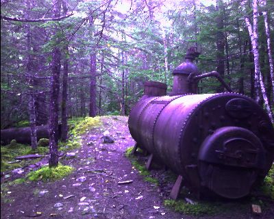 The old steam boiler |
are my feet as durable as Silly Putty of a small building, rusted out cans half buried in the moss, and old stoves nestled in the damp ground. The log structures that housed them are long gone. I meet a ranger and his wife when I return, taking down the orange markers used for foul weather navigation for the season.
The sky is mostly cloudy this morning as I start the long climb up to the Pass.
 |
 Atop Chilkoot Pass |
busily getting supplies ready to fly out for the helicopter
coming tomorrowend of the season. We share our summer experiences, both eager for the onset of
a cold, snowy winter. I eat a snack in the day use shelter, and decide to head
on as the rains continue. Vertical walled Echo Canyon punches through
the rocky terrain that lies below as I work my
a half dozen miles to Lindeman City. waypass two grouse red squirrel
The other two depart early to reach the road and hitch a ride to Fraser to
continue their journey south. I leave the cabin for
I need to be back in Colorado by the 16th. I find a bus that will take me to
Denver, but two days late. I don't feel like spending $800 in ferry and plane
tickets from Juneau, so I think I'll do what I'm accustomed to on long distance
trips. Let me try hitching a ride. The 29th year of the Klondike Road Relay is
tonight, where one hundred fifty teams of ten run the hundred miles to
Whitehorse. Each runner gets a ten mile stretch--xxx. Tonight it's in the
pouring rain. I ask around at the start 100 or so miles Three gigantic plates of
pasta and salad after four months of looking up at the world, it feels good to
be at the top The customs officer stared intently at my pack, kayak shafts
poking into the air, stove fuel stuffed in a side pocket. "Can I have the person
in the backseat step out of the car?". Oh great, this is going to take forever.
Why are you carrying antifreeze?" ntifBob amd Karen chuckle howl of dogs
Chilkoot with 1500 pounds of food 500 of gear dog mushing small blue car. Why is
it turning around? You're going Ian Moe Fin Mable over seven hours of hitch a
ride across from the airport I'm back there for a third time permit usually
$50.80 strong, dangerous gusts of 2 knots The area was only active for four
years
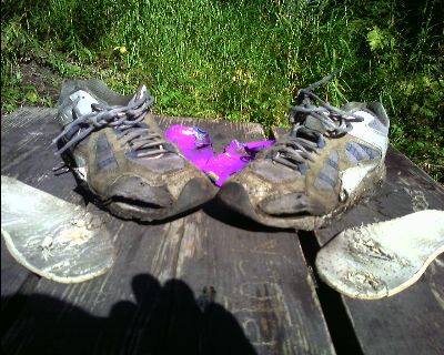 The Montrail Hardrock running shoes after 1000 miles on the Continental Divide Trail and a summer of town stops on the Inside Passage. |