This morning I left my parent's place, walked across the street, and headed up Buck Creek. The morning sun was hot, the trail was covered with overgrown vegetation, and the flies were swarming all over me (at least the mosquitoes aren't bad—not yet, at least). I reached Red and White mountain a while later, and bushwhacked down to the dirt road. (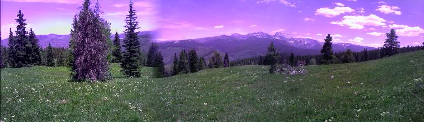 Inset: The Gore Range.)
I eventually reached Flagstone Park, and descended down to the Piney River. Some of the trails in the area are in the middle of nowhere and difficult to follow—used mostly during hunting season. They're full of overgrown grasses and plants from the plentiful snowmelt waters that drench the area each spring. (
Inset: The Gore Range.)
I eventually reached Flagstone Park, and descended down to the Piney River. Some of the trails in the area are in the middle of nowhere and difficult to follow—used mostly during hunting season. They're full of overgrown grasses and plants from the plentiful snowmelt waters that drench the area each spring. (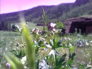 Right Inset: The Piney River Valley.) As evening approached, I reached Elliott Ridge—a long, rolling ridge above timberline that stretches for miles. As I dropped towards Cataract Lakes, the snow quickly disappeared, and I saw the chain of life quickly return one link at a time. I heard the echoing chirp of a pika, a couple of marmots running through the wet meadows, a noisy squirrel in a nearby tree, and a deer trotting away when it noticed my presence. I put my headlamp on at 9:30, and soon came across a few campers wearing full raingear to ward off the bugs. I decided to head on for another twenty minutes and made camp.
I was up at 5:30am, and on the trail fifteen minutes later for the long trek to Silverthorne along the Gore Range Trail. I passed in the shadows of the mighty peaks in the Gore Range, hiking on trail that dives in and out of the many creeks it travels across. The mosquitoes are everywhere, viciously attaching themselves to my arms and legs as I hike. I have a sample packet of bug repellent that's been sitting in my pack since New Mexico, and figured this would be a good time to use it. I'm not big
on the idea of using DEET on my skin without a town stop for several days, but since I'll be showering this afternoon and washing the not so friendly chemical off me, I'll give it a try. As I wiped the towelette onto my leg, I squashed almost a dozen mosquitoes turning my leg red with spots of blood. For the next four hours, they swarmed all around me, but I remained virtually untouched. It was a great feeling, but as it wore off after four hours, they were all over me again (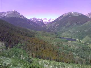 Inset: Black Lake and Dora Mtn.)
As I stopped to fill my water bottles at one point, I heard a loud crack nearby. I figured it was a trail user or animal, but a few seconds later I heard the thunderous crash of a large tree falling to the ground. After eight hours on the heavily wooded trail through record setting heat (the upper 80s at 9,000ft) and abundant mosquitoes constantly swarming all over me, I was done—finally.
Inset: Black Lake and Dora Mtn.)
As I stopped to fill my water bottles at one point, I heard a loud crack nearby. I figured it was a trail user or animal, but a few seconds later I heard the thunderous crash of a large tree falling to the ground. After eight hours on the heavily wooded trail through record setting heat (the upper 80s at 9,000ft) and abundant mosquitoes constantly swarming all over me, I was done—finally.
Silverthorne
I ended up taking a day off, staying with my aunt and uncle, spending the 4th of July in town. I seriously thought about hitching a ride to Avon to spend the holiday with some friends, but the thought of heavy alcohol usage and intense climbing the next day turned me off to that idea.
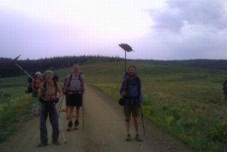
As I started up the trail this warm, sunny morning, I signed the trail register and noticed the names Nemo and Pouch just before me. A quarter mile later, I saw them taking a break and we filled each other in on our adventures and near death experiences (no, just kidding) since we last saw each other in the Cochetopa Hills. The climb to Ptarmigan Pass was long and very warm, until the skies turned black nearby. The Gore Range I was hiking through two days earlier now had dry lightning striking the beetle killed trees. There hasn't been any rain in weeks, and fire restrictions have recently gone into effect. Fortunately rain soon followed, and the surrounding skies continued to turn increasingly dark and threatening. Above us was some gray clouds, something we weren't too concerned about. The trail was mostly above treeline at this point, and wound around peaks, along ridges, and through krummholz zones. (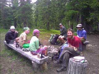 Inset: Team F-Yeah.) As we descended to the South Fork of the Williams Fork Creek, I heard the call of another hiker, "Poop" (yes, there's a story behind that). "That's Haiku" uttered Nemo. "Team F-Yeah?" I asked. "Yep, that's them." The crack of thunder in the distance continued, followed by some light rain. I took out my umbrella I haven't used since New Mexico, and had the the rest of the "team" arrive. Shaggy arrived shortly, along with Bethany and Star. I met Star briefly in Pagosa Springs, where she was with her brother d=rt, who is now hiking the CT towards Denver. The light rain subsided as we continued our roller coaster ride from heavily wooded creeks to 12,000 foot ridgelines and back. I spotted Mt. Holy Cross a few times, now just a small point on the horizon, with the snow filled cross barely visible. Off to the east, the skies were black, probably giving the Front Range a needed dousing of rain. During one of our dives into the trees, we passed a hunting camp, complete with a canvas tent torn to shreds, broken lanterns, food containers and trash strewn all over the place, a cooler full of sodas, and even a working chainsaw—yes, a working chainsaw! (
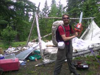 Inset: What's left of the hunting camp.)
All likely still here from a hunting party that tried to escape from a winter storm last September. This is the third time I've seen this kind of crap on the trail, and hopefully one of the last. The trail disappeared several times, obliterated by lack of use, rockfall, or overgrown meadows. The "official" trail goes over the Fourteeners Grays and Torreys on the other side of I-70, but suprisingly, we saw an old weathered trail sign on a saddle above several poorly maintained switchbacks with "Continental Divide Trail" clearly visible. (
Inset: What's left of the hunting camp.)
All likely still here from a hunting party that tried to escape from a winter storm last September. This is the third time I've seen this kind of crap on the trail, and hopefully one of the last. The trail disappeared several times, obliterated by lack of use, rockfall, or overgrown meadows. The "official" trail goes over the Fourteeners Grays and Torreys on the other side of I-70, but suprisingly, we saw an old weathered trail sign on a saddle above several poorly maintained switchbacks with "Continental Divide Trail" clearly visible. ( Right Inset: Star finishing the last climb of the day.) We dropped into the next drainage, and set up camp with a good half hour of daylight still upon us.
The day was full of ups and downs—many of them. Our first climb was up to Jones Pass and around Henderson Mine, where we stayed above treeline all day, except for the descent to Berthoud Pass. The trail for the most part stays on the divide, diving off to one side every now and then where the peaks get too steep to climb or technical in nature. As we traveled around Vasquez Peak (near the ski resort of Winter Park), the trail started to switchback down towards the mine, which was likely part of the bad weather route. "What! Were not supposed to go below treeline!" We promptly turned around and tried to find a trail that stayed above the trees as shown on our maps. Nothing. Where did it go? Not finding anything, we bushwhacked around the peak on the steep slopes to a ridge that dives down from an adjacent peak. Seeing the trail over a thousand feet below, we began the steep descent through scree and krummholz to the tread below. It began its long, arduous ascent up Stanley Mtn. and the roller coaster ride continued towards Berthoud Pass. We collapsed behind the Atlantic/Pacific watershed sign for a break, and watched tourists from all over the country take their pictures next to the sign. A half hour later, we were climbing towards 13,000ft peaks again. There were thunderstorms off to the west, but they stopped their advance towards us as the late afternoon progressed. The wind picked up as we climbed higher, and we struggled to find a sheltered spot from the wind until nearing Witter Peak. The Denver skyline was visible to the east, Longs Peak in Rocky Mountain National Park pierced the sky to the north, and off to the west lie the jagged Williams Fork Mountains and the Gore Range. We built camp after struggling with the last half mile of climbing in the strong winds, and watched the sunset turn the shrinking storm clouds a pink glow as the sun dropped behind the distant peaks to the west.
There was a light breeze striking our camp at 12,700ft this morning, and our roller coaster ride continued. After climbing our first thirteener yesterday, we did three more today, finishing with James Peak. The climb from Mt. Bancroft to James started with a steep descent down talus rock, followed by a class 3 scramble up large boulders scattered along the narrow knife edge ridge. (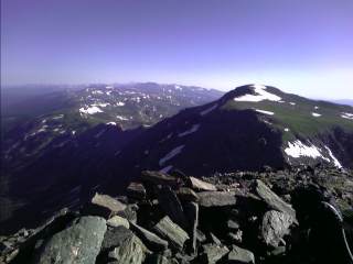 Inset: Looking at James Peak.)
We were partially sheltered from the strong winds at times as we climbed the knife edge between the two peaks. After a break on the top of James Peak behind a rock wall sheltering us from the wind, the long descent off the peak began. We were still on the Divide, but over a thousand feet lower. The winds weren't as strong, and the temperatures were comfortable. As the day wore on, we descended into the trees for the first time today. Not more than fifteen minutes later, the sound of thunder traveled through our ears. (
Inset: Looking at James Peak.)
We were partially sheltered from the strong winds at times as we climbed the knife edge between the two peaks. After a break on the top of James Peak behind a rock wall sheltering us from the wind, the long descent off the peak began. We were still on the Divide, but over a thousand feet lower. The winds weren't as strong, and the temperatures were comfortable. As the day wore on, we descended into the trees for the first time today. Not more than fifteen minutes later, the sound of thunder traveled through our ears. ( Right Inset: Heading below treeline as the sky opened up.) Twice the sound of thunder pulverized our ears as the lightning struck less than a hundred yards away. We stopped to fill our water bottles and make dinner as the skies to the north continued to grow darker, and camped along the edge of the meadow with the Indian Peaks Range looming in the distance.
Most of today was spent traveling around the dammed up Colorado river that forms several large lakes. Along the way we passed a strange boiler type device (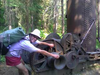 Inset:
Is it a Cabbage Patch Kid factory, or maybe a Willy Wanka Oompa Loompa machine? Actually it's a Steam Donkey.) we needed to check out. When we reached Monarch Lake, we met the ranger, stationed at a permit office/visitor information cabin right on the trail. (
Inset:
Is it a Cabbage Patch Kid factory, or maybe a Willy Wanka Oompa Loompa machine? Actually it's a Steam Donkey.) we needed to check out. When we reached Monarch Lake, we met the ranger, stationed at a permit office/visitor information cabin right on the trail. (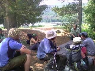 Right Inset: Getting a local history lesson.)
We asked her about the boiler type device we saw earlier, and she proceeded to give us a twenty minute lecture on the history of the area—the railroad, logging, and the flumes that were constructed to get the logs thousands of feet down to the lake. The Steam Donkey, (one of only twenty or so left in existence) was one such device used to pull the logs onto the flume, where it would travel down and hit the lake with enough force to submerge and resurface, jumping twenty feet into the air.
Right Inset: Getting a local history lesson.)
We asked her about the boiler type device we saw earlier, and she proceeded to give us a twenty minute lecture on the history of the area—the railroad, logging, and the flumes that were constructed to get the logs thousands of feet down to the lake. The Steam Donkey, (one of only twenty or so left in existence) was one such device used to pull the logs onto the flume, where it would travel down and hit the lake with enough force to submerge and resurface, jumping twenty feet into the air.
Grand Lake
We stopped for dinner as the skies unloaded everything they had at us while walking down the main drag in town. Earlier today, the weather has cooperated for us for the most part, with some brief periods of rain here and there. I'm writing this from the kitchenette at the Spirit Lake Lodge the seven of us are staying in tonight, with our gear strewn everywhere. It's a one bedroom, two bed unit, and one has to carefully travel from one room to the small kitchen/den area to avoid stepping on someone or their gear.
It's noon, and we're all still here, slowly packing up and leaving. Everyone left at different times, with me being the last. I called the veterinarian who performed the seven hundred dollar surgery to remove several lumps from underneath my dog's skin a few days ago, and Shep is doing great. ( Inset: .)
The trail wound its way out of town, and began the long ascent to reach treeline. It approached Cascade Mountain with strong winds blowing me around like a bottle floating in rough seas for the next several miles. Longs Peak was clearly visible to the east through the late afternoon sun, and I could see the trail sheltered in the trees thousands of feet below me. I reached the rest of the group and noticed worried looks on their faces. "Star's missing" uttered Nemo. A few of them took a shortcut straight down the steep slopes and now one is still unaccounted for. She met Trey, another thru-hiker and they headed to Illinois Creek and haven't been seen since. We all started yelling out the Team F-Yeah emergency/distress call: "Poop", "Poooop" with no response. After a good half hour of running up and down the trail, across the creek, and up the hill, we decided to see if they followed the creek downhill. Our fifteen mile day was now turning into a twenty mile day—which is good—as we continued to yell out the group's "international distress call—Poop, Poooop." As the dim sky darkened completely, we heard a faint voice from below. Haiku ran ahead to the source and saw two tents set up on the old logging road. It was them. He ran back up the trail to get us, and we headed down. Getting "lost" (also known as not-exactly, don't-know-exactly-where-I-am, or simply misplaced) around here is so easy to do. Logging roads are everywhere, and when approaching an intersection, it's unknown which way the rest of the group headed. With the seven of them gathered around cooking dinner—and me eating my Doritos, tortillas, and cheese for dinner—we all had a laugh about our many where-the-h%#@-am-I experiences.
A little after noon or so, I stopped to fill water bottles while the others headed on. At the top of a knoll, I passed an intersecting trail. Oh great, what is this, I asked myself. As I was about to go ahead, I pulled out my map, and noticed the trail taking an abrupt left turn that appeared to head towards Willow Creek Pass. It was unmarked, not heavily used, and... I'm taking it! As I saw the road over Willow Creek Pass ahead, I breathed a sigh of relief. The early afternoon sun was hot, and now I had a several thousand foot climb up to Parkview Mountain. The dirt road I was on eventually turned around the mountain—and not on my map—so I bushwhacked up to the heavily timbered ridge, which had plenty of deadfall I had to climb over, under, or around. Out of nowhere, I saw flagging follow the ridge up to another road junction. ( Inset: The CDT trail.) I continued up the steep ridge and climbed to timberline. After gaining the long summit ridge, with views from Longs Peak in RMNP to the Gore Range, I saw a shelter on the summit another thousand feet above me and a mile away, and slowly worked my way towards the top. (
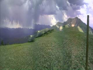 Inset: Parkview Mountain below the building storm.) The long descent was steep, and involved more bushwhacking through heavy timber to get to the road below. There was occasional flagging marking the route that was filled with downed timber and tight trees. After several hours to get over Parkview Mountain, it was another long climb to get up to the Continental Divide. I followed another dirt road several miles until it paralleled the Divide, and bushwhacked my way up to Poison Ridge. The ridge was dotted with trees, but still provided excellent views of the surrounding terrain. In the middle of nowhere, I came across a cairn, and a small sealed piece of PVC pipe—a summit register. I opened it, and read the Colorado Mountain Club register. The CMC has trail registers on all the summits of Colorado's Fourteeners, but I've never seen one on a non 14er trail before. I signed it, and saw the names of a few other thru-hikers several days ahead. As I approached treeline, I saw a tent near the trail and stopped. It was Bob, a business professor at a university in Virginia, whose adventures in life made it difficult to hold a job for more than a few years until recently. Now he's able take his summers off—spending this one section hiking south from the Great Divide Basin to Silverthorne. The sun was long gone, and with the approaching darkness, I set up my camp.
There was a steady breeze blowing through the lofty camp last night, and my ground cloth was full of pine duff and other debris blown all over my camp. We wished each other luck on the rest of our journeys, and I was on my way. The trail continued its wild ride above and below treeline around peaks, and in and out of the many valleys. I headed down to a small creek, which served as my first water source for the day, and followed it for a half mile. Something didn't feel right. I looked at my map and saw the trail took a sharp left turn a quarter mile behind me. I turned around and slogged back uphill. Fifteen minutes later, I saw several hikers gathered around a lone cairn off the side of the trail staring at their maps. "Hey, it's Skygod!"
( Inset:
Combating boredom on the roads: "You do that again, and I'll throw this cow pie
at you.") We shared stories of the usual getting lost, routefinding, and everything else this trail has thrown at us since we separated yesterday. We turned off at the lone cairn and traveled cross country along a hard to follow old road, and bushwhacked up to the Divide. After several more hours of ups and downs, the dusty road finally headed down for good. It dropped past Chimney Rock, and into the valley below. The day was sunny, and the temperatures hot. The last water source was ten miles back, and were could all use some of it right now. Well, it just so happens a friend of a rancher was traveling down the road on his ATV, and offered us water—and he had plenty of it. The only creek in the area was brown and muddy from all the cattle roaming about. We sat down on the side of the road and emptied is five gallons of extra water he had from his camp nearby. (
Inset:
Combating boredom on the roads: "You do that again, and I'll throw this cow pie
at you.") We shared stories of the usual getting lost, routefinding, and everything else this trail has thrown at us since we separated yesterday. We turned off at the lone cairn and traveled cross country along a hard to follow old road, and bushwhacked up to the Divide. After several more hours of ups and downs, the dusty road finally headed down for good. It dropped past Chimney Rock, and into the valley below. The day was sunny, and the temperatures hot. The last water source was ten miles back, and were could all use some of it right now. Well, it just so happens a friend of a rancher was traveling down the road on his ATV, and offered us water—and he had plenty of it. The only creek in the area was brown and muddy from all the cattle roaming about. We sat down on the side of the road and emptied is five gallons of extra water he had from his camp nearby. (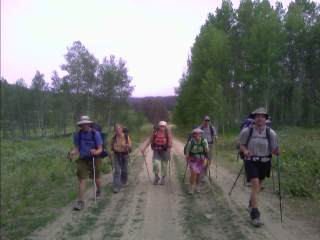 Inset: Team F-Yeah Heading into Steamboat tomorrow to terrorize the town.)
We continued down to the paved highway and made camp a mile later as darkness crept up on us.
Inset: Team F-Yeah Heading into Steamboat tomorrow to terrorize the town.)
We continued down to the paved highway and made camp a mile later as darkness crept up on us.
At 5:45am, we were all awaken by raindrops pelting us in the face. No one set up their tents last night, and we were packed and ready in less than half an hour.
Pouch, Shaggy, Haiku and I separated from the rest of the group and headed off to Muddy Pass on Hwy 40. We passed each of the next seven mile markers every fourteen to fifteen minutes apart. As we reached
Highway 40, our four mile an hour pace had worn us out, and we were ready for the usual three things: food, shower, and laundry. Less than ten minutes later, we had a ride into town.
Steamboat Springs
We gazed out the windows of the back of the pickup truck looking for a breakfast place to start our town visit. We spotted Star on the sidewalk, got dropped off, and followed her to breakfast where Bethany, Nemo, and Trey were anxiously awaiting their first real meals since Grand Lake.
The original plan was to take today off and be on the trail first thing tomorrow morning. Well, it's a day later—Friday the 13th—and we're still here. Everyone is worn out from the endless vertical we've hiked since Silverthorne. Some have sore feet, backs, or some other body parts that needs rest. After taking a dip in the hot tub, Shaggy, Trey, and I did anything but rest. We headed to the bars after taking a dip in the hot tub. (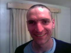 Inset: Uh oh, maybe I shouldn't have taken so much off.)
On the second day off, no one traveled very far; maybe the library across the street, or on the bus to the grocery store. There was usually someone in the bedroom taking a nap, or on the couch watching TV. A few of us headed to the town's popular weekly concert series for the opening band, but returned as the skies grew black. On our way out, it seemed like the entire town poured into the lawn seating area for a band we could hear from our motel room porch.
Inset: Uh oh, maybe I shouldn't have taken so much off.)
On the second day off, no one traveled very far; maybe the library across the street, or on the bus to the grocery store. There was usually someone in the bedroom taking a nap, or on the couch watching TV. A few of us headed to the town's popular weekly concert series for the opening band, but returned as the skies grew black. On our way out, it seemed like the entire town poured into the lawn seating area for a band we could hear from our motel room porch.
After gathering our belongings and turning our living quarters from what looked like a Disaster Area to a motel room, we headed across the street to the bus stop and took it to the other side of town. There was eight of us together trying to hitch a ride up to the Pass. That's probably a little intimidating to motorists, so some of us sat under a tree while Star, Nemo, and Haiku stuck out their thumbs. After an unsuccessful half an hour, I decided to hike up the highway to a gas station and found a ride. It was another hot day, with the usual frequent swatting of mosquitoes as I hike along the Wyoming Trail near or on the Divide, with its gently rolling terrain, dotted with ponds and meadows. The skies continued to darken as the afternoon progressed, with some light rain beginning to fall as the thunder roared ever closer. Suddenly, I was pelted by pea size hail and grabbed my umbrella. The weather grew more intense by the minute. The pea size hail was now marble size hail, and I sought shelter under a low tree in the dense forest. It was coming down hard—really hard. ( Inset: Three inches of pea to marble sized hail on the ground.)
I gazed at the heavy rain and hail slicing its way through the sky and listened to the thunder roar over me. An hour or so later, the storm was over. There was over three inches of hail on the ground in many places, and my feet were instantly soaked as I continued up the trail. I was passed by several mountain bikers earlier today, and two struggled along the wet trail as the storm ended. An hour later, the clouds continued to grow vertical, and it was time for round two. This time I decided to call it a day. The rain intensified as I threw up my tent under the rainy skies. I was hoping to continue on to Buffalo Pass as a night hike, but the dull roar of thunder is all around me as light rain splashes onto my tent. As I write this at 9pm, the ground is still covered in an inch of cold, icy hail, and the gray, menacing skies look ready to open up at any minute.
Inset: Three inches of pea to marble sized hail on the ground.)
I gazed at the heavy rain and hail slicing its way through the sky and listened to the thunder roar over me. An hour or so later, the storm was over. There was over three inches of hail on the ground in many places, and my feet were instantly soaked as I continued up the trail. I was passed by several mountain bikers earlier today, and two struggled along the wet trail as the storm ended. An hour later, the clouds continued to grow vertical, and it was time for round two. This time I decided to call it a day. The rain intensified as I threw up my tent under the rainy skies. I was hoping to continue on to Buffalo Pass as a night hike, but the dull roar of thunder is all around me as light rain splashes onto my tent. As I write this at 9pm, the ground is still covered in an inch of cold, icy hail, and the gray, menacing skies look ready to open up at any minute.
I broke down camp this morning, with an inch or so of hail still on the ground. It was chilly, but the sun was soon shining brightly as I descended to Buffalo Pass. The hike through the Park Range was fantastic. It was almost completely above treeline, with numerous lakes dotting the area in every direction. (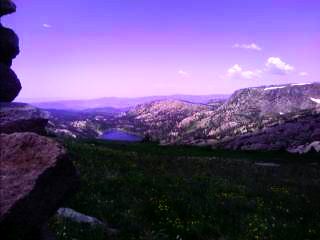 Inset: The Park Range north of Steamboat.)
Rabbit Ears Peak is clearly visible, along with the haze from the fires in Utah, Nevada, and California. I passed several groups of backpackers heading back to Buffalo Pass as the end of the weekend arrived, and wondered how I'd feel if I had to go back to work tomorrow. I eventually left the range and descended towards the Elk River valley. The area is full of burned timber from a large fire that swept through the area a few years back. Most of the trunks were still standing, covered in soot and readt to fall at any time. (
Inset: The Park Range north of Steamboat.)
Rabbit Ears Peak is clearly visible, along with the haze from the fires in Utah, Nevada, and California. I passed several groups of backpackers heading back to Buffalo Pass as the end of the weekend arrived, and wondered how I'd feel if I had to go back to work tomorrow. I eventually left the range and descended towards the Elk River valley. The area is full of burned timber from a large fire that swept through the area a few years back. Most of the trunks were still standing, covered in soot and readt to fall at any time. (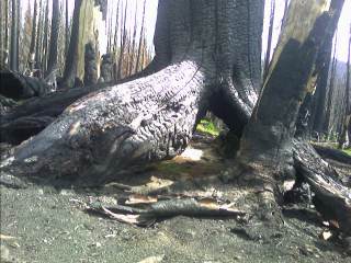 Inset: The burned out trunks from the Grizzly Fire years ago.)
I headed up the river, gathered some water, and camped above the valley with the echo of cattle below me and the Elk River Valley laid out below me.
Inset: The burned out trunks from the Grizzly Fire years ago.)
I headed up the river, gathered some water, and camped above the valley with the echo of cattle below me and the Elk River Valley laid out below me.
I'm a little worn this morning. I did thirty three miles yesterday, and I can definitely feel it in my feet. I started the morning out slow, and found it difficult to go any faster with the intense sun staring me right in the face. It was a very warm afternoon, and I found myself downing a quart of water at every source. Today also marks the end of carrying only a quart or two of water at a time since northern New Mexico. The trail stays on the divide for several days, in dry, dense tree cover. There are no lakes dotting the divide, nor is there large meadows providing water every few miles. In a few days I'll be in the Great Divide Basin, a hundred and twenty or so mile dry stretch famous for providing hikers with water in a variety of different colors. On the other hand, if I can survive New Mexico's Chihuahuan Desert, this should be no problem.
Continue to Southern
Wyoming