Helena
My ride from the Canadian whose traveling around the entire U.S. for five months dropped me off at a grocery store at the edge of town, and I picked up my items for the three day hike to Lincoln. I headed out to the parking lot, and tried to yogi a ride to the other end of town as people left the store. There's a truck stop where I figured I could get a shower and do laundry. I decided against spending the night in town—I've taken enough zeros, and while my feet are reddened again, clean socks and a shower should take care of that. I found a ride from Rose, who told me I'd have to head home first and enjoy breakfast with her and her husband Darrell. Ok, I can handle that! When I arrived at their home, she pulled out several maps that covered a wide area north of Lincoln. I also called a Ranger Station near the burn area to find a route north. Well, that didn't turn out to be very useful. Most the trails aren't on the map I'm looking at, and the burn area will likely change before I get there. I thought these maps were going to solve my problems, but it doesn't look like that will happen. Now most of the Bob Marshall Wilderness is closed. A reroute plan I obtained earlier online from the CDTS is now mostly useless. After breakfast, the two were on their way to a meeting for their Watercarvers Guild Band—playing new contemporary folk music around the Northwest. They dropped me off at the Chinese Buffet restaurant for a little AYCE (all-you-can-eat). Ok, what do I do after this? I've been trying to call a local trail angel here in town since this morning. Thomas (Trailname: Good2Go) hiked the PCT two years ago, and now helps CDTers during their town stay. I'm sure he's out for the Labor Day weekend, but I'll try one more time. I called him, expecting to get his voicemail, and got a "hello" instead—and he can pick me up in an hour! Alright, I have a place to shower, do laundry, and rest up. This is great. I've been here at the Chinese place now for over three hours, working on my fifth heaping plate as I catch up on my journals. As I sit here waiting to Thomas to show up, stuffing myself with their selection of over two dozen food items, I'm starting to get some dirty looks from the manager. She looks at me every now and then, talking to another waitress in their native tongue. I'm just waiting for her to come over, lean over the table waving her finger wildly at me, and shout at me with her thick accent: "YOU HAVE BEEN HERE FOR OVER THREE HOUR! YOU MUST LEAVE!!" Well, fortunately that never happened, and I left a thirty five percent tip as I continued to finish off every last morsel resting on my plate. Soon thereafter, Good2Go showed up and took me to his place. It's a small one bedroom apartment in a quiet neighborhood, but Team F-Yeah—now down to about half the size they were when I saw them last—all managed to comfortably stay here a few days ago. I called Mary, who is a friend of Rose (she took me to the Chinese restaurant). She and her daughter man the fire towers in the Bob Marshall complex, and know the area like the back of their hand. I called a few more Ranger Stations with limited success. Nobody seems to know what's going on in the Scapegoat and Bob Marshalls—conditions are changing daily with the strong winds and low humidity, and usually the person that answers the phone has limited knowledge of trail conditions. I have a map in front of me I'll use to choose a few different routes. I've looked online for information, but that lacks specific trail detours and some of the closure maps are impossible to read. My next option is to visit the Ranger Station in Lincoln when I arrive in a few days. If that doesn't work, I'll hike the Flathead River to Glacier NP—
provided it's open.
Along with recharging my PDA/phone at every town stop, I also move all the pictures taken from the last resupply (or power outlet) from the device to my MiniSD card. Well, something went wrong, and I lost all the photos I had taken from Anaconda to Helena (except for a couple I had already resized and put on my website—all done from this PDA). Fortunately, none of them stood out as anything special. All the shots were clouded in a thick mass of smoke. If I was going to lose some pictures on the trail, this was the right section for it to happen. Unfortunately, backing up my pictures to a CD isn't easy to do out here. Anyway, in other news, Thomas is off to do a float trip on a nearby river on this bright, sunny Labor Day. The three dropped me off back at MacDonald Pass on their way, and I started my trudge northward. My right ankle is swollen again just below the ankle bone—which hasn't happened since Lima, MT—and other than being a little weak, it doesn't bother me at all. Thomas is an active runner, and his sister is a doctor. He takes Ibuprofen every now and then to help reduce swelling. Last night I tried taking one to see what it could do for my ankle. I haven't needed any pain medication for anything in many years, and hope I don't need it anytime soon. I padded around the area with moleskin, and will see what it looks like this evening. (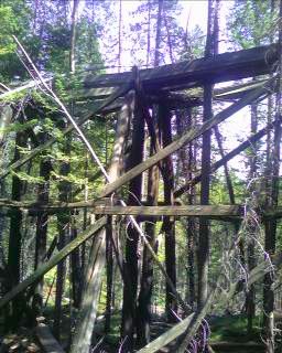 Inset: The last still standing railroad trestle in the area.) On the way to Mullan Pass, I passed an old rickety railroad trestle, which had trees growing all around and through the old dilapidated structure. An hour later, I got a brief history lesson—and temperature reading of 84° from the car's display—from a local driving through the Mullan Pass area. There are some old buildings below that used to be part of a coal mine, and he described a memorial he and his father erected in the area years ago for some pioneers that lived around here. They drove on, and almost two hours later I filled up on water for the first time today, and met some local ranchers moving their cattle from one pasture to another. Jim and Carrie are from Avon, MT and I shared some of my experiences with them. They told me the local newspaper reported yesterday as the 51st day of 90° or above in Missoula this summer. I'm glad I was in Colorado in July. The water sources around here are starting to dry up, and I've been carrying a gallon with me today. It's definitely not helping my foot issues, but once I hit Lincoln in a couple days, water should be plentiful for the rest of the trip. I walked around the open fields near Dana Spring this evening looking for a flat area to set up camp. I threw my groundcloth down, emptied my pack, and slept under the stars.
I saw several deer lazily grazing in the area as I was awakened by the dull rumble of thunder noisily grumbling all around me. There are dark clouds out to my west and the sun trying to poke through to the east. (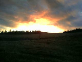 Inset: Sunrise from Dana Spring.) A little after 7am, with some drizzle in the air on this warm morning, I packed up and headed over to Dana Spring. The spring is a vertical galvanized pipe in a fenced-in area. The water level is quite low, and there's also a note on the cover reporting a dead rodent was pulled out a couple days ago. I tied a piece of parachute cord to the neck of my water bottle and lowered it down. I was able to use my trekking poles to submerge the bottle and fill it up. I pulled it out, filled my other containers, treated the water, and repeated the process a couple more times. Under the threatening clouds and smoky air, I climbed my way up and down the trails and old roads as I worked my way north.
 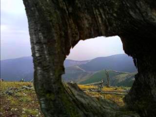 I heard the clap of thunder every several minutes and reached for my umbrella a couple times only to have the rain stop a few minutes later. Will all the lightning—and little rain—start any new fires? Most hiking today was in the trees, reaching a treeless vista every now and then. (
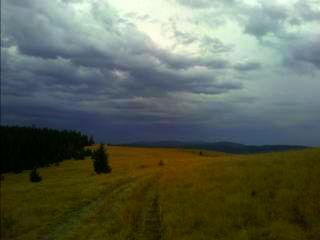 Inset: Rain clouds forming above Stemple Pass.) I stopped early for the day around five as the thunder roared all around me. There's a water source about a mile from here just off the gravel road, which will likely be my last one for another ten or fifteen miles.
I fell asleep to the bugling of elk last night, and woke up to clouds and the splash of light rain on my tent. I found it difficult to get going this morning, and I fell asleep again. I was on the trail by 9am, and filled up on water for another ten mile dry stretch to Flesher Pass. The sky was cloudy, with the occasional dark, threatening cloud passing by. As I reached Flesher Pass, the clouds started to clear out, and the bright sun helped warm things up. At the trailhead, I noticed several jugs of water near a picnic table, and they're marked "CDT hiker water cache." If this wasn't here, I'd be walking a mile along the highway to a find a muddy spring. A Trail Angel from Missoula put them here, and shows up every now and then to refill them.
( Inset:
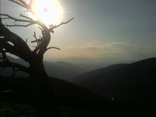
The sun slowly sinking behind the smoky peaks of the Bob Marshall Wilderness.) As evening approached, I climbed onto a several mile long stretch of treeless ridgeline. The Bob Marshall and Scapegoat Wilderness was to my north—largely closed from the fires—and other than the strong winds bringing a chill to the air, the setting sun and rocky, granite outcrops brought a bit of warmth to my spirit.
Inset:
The sun slowly sinking behind the smoky peaks of the Bob Marshall Wilderness.) As evening approached, I climbed onto a several mile long stretch of treeless ridgeline. The Bob Marshall and Scapegoat Wilderness was to my north—largely closed from the fires—and other than the strong winds bringing a chill to the air, the setting sun and rocky, granite outcrops brought a bit of warmth to my spirit.
Late last night as I woke up and rolled over in my bag on the cold, rocky ground, I noticed a lack of starlight gleaming into my eyes. I looked around the night sky from my camp perched atop a treeless ridge and could see the dark bottoms of rain clouds. I had stuck my trekking poles firmly in the ground—which serve as tent poles—in case of bad weather, but I still had to pound the stakes into the hard ground and set up the tent. I've done this before, all from the comfort of my sleeping bag, but that was in a well protected area with no wind and soft ground. The air was dry, and knew there was a good chance nothing would happen. I'm taking that chance. 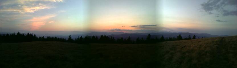
I was lucky, no rain last night. There's a stiff breeze blowing this morning, and I waited until the sun struck me with its warmth before I hurriedly packed up and headed down to Rogers Pass. Out of curiosity, I left the trailhead area and started hiking the hundred or so feet to the pass to see where the northbound trail picked up—which is probably well signed with fire closure information. As I neared the pass a few minutes later, the third car that saw me with my thumb out picked me up. He was on his way to Lincoln to do some bird hunting, and dropped me off in the center of town.
Lincoln
Ok, it's 9:30am, now what do I want to do? I broke down and got a motel room, where I cleaned up, threw my pack contents all over the place to air out, and headed over to the grocery store. The town is compact and easy to get around, and made famous by the Ted "Unabomber" Kaczynski (who lived in the area) case years ago. I bought too much stuff at the store, so it looks like I'll be having lunch, and maybe even dinner, in the room. There's a microwave and fridge, so eating all afternoon should be convenient. I called the Lincoln Ranger Station and was provided with some useful reroute information. They sent me to the Seeley Ranger District, who in turn sent me to the Spotted Bear RD. The burn area encompasses such a large area, numerous Forest Service offices are affected. I have a route planned from Holland Lake, and I hope this works. As I write this, I flipped on the TV at 10:15pm to see if I can catch some weather info. There's a series of cold fronts coming through the area over the next several days, with scattered rain possible. At the higher elevations, where I'll be, that could mean snow. I have an extra layer of warm weather gear I picked up earlier at the Post Office, and it might start to come in handy. As I sit here in the motel room figuring out my route north, I have a lump in my throat growing bigger—this is the home stretch. No more new states to enter, and only a few more town stops. I'm disappointed that I'll miss some of the most spectacular trail in Montana—no Chinese Wall, no Scapegoat Wilderness&, no Great Northern#8212;but I can think of worse things that could happen. I have part of the Bob Marshall and Great Bear Wilderness Complex to cross, and then it's Glacier National Park. Before I know it, I'll be in Canada! Of course, these weather systems barreling towards me from the north could change things, but the fact that I hiked here through five states still amazes me. Montana seemed so far away for so long, and now I'm almost to the northern border. I used my PDA phone to call the long distance numbers for Glacier to get permit information and closure dates for the different areas of the park. Lincoln didn't have cell service until the last few months. As much as I don't care for these things on the trail, they can come in really handy. I called the Helena Post Office from the middle of nowhere near Anaconda on a Saturday, and had my warm clothing forwarded. Without the phone, I would have been hiking with several extra pounds of gear through eighty degree temperatures. In Glacier National Park, most of the campstores and services close sometime in September. Each area has a different closing date, and I had to figure out how to resupply halfway through the Park. Carrying all my food through didn't appeal to me with the extra weight in clothing I have with me, and my worn out feet. I think I'll head to the nearby town of Babb.
I was out on the road with my thumb out a little after 11am. There was a moderate amount of traffic, but nobody seemed to stop for me. Well over an hour later, I got a ride from someone heading a few miles out of town. It won't do me much good, but it will feel good not to be in the same place all day. Unfortunately, there's a speed limit of 70 out here, and who's going to stop for me at that speed? I feel worthless—at least I can camp in the flat area behind the fence if I'm still here tonight. After a good hour and a half, I crossed the road and got a ride back into Lincoln from a local who lives in a nearby subdivision. She even took me to a local beef jerky processing plant on the way for a piece of cardboard. I carefully drew out "Holland Lake / Hwy 82" with the magic marker. Ok, let's try this again. (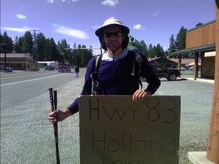 Inset:
Will I ever make it out of town?)
After forty five minutes, I was starting to ask myself why hitching out of here was so difficult. It's supposed to be easy in Montana! I headed across the street to the gas station and after fifteen minutes of asking around, found a ride. It took me three rides and over eighty miles of travel, and I'm back on the—actually a— trail again. There is a fire information board in every town, giving updates on conditions and trail closures. There is rain the air, and dark swirling clouds above. I started my trek with Andrea, who brought me up to the Holland Lake Trailhead. We hiked for a quarter mile or so until my trail took a turn, where it headed away from the lake on the long climb up to Holland Pass. Halfway up, I could look down on the valley and see rain pounding areas to the north over the Mission range. There were glaciers clinging to its steep slopes dropping away from the endless pointy summits. (
Inset:
Will I ever make it out of town?)
After forty five minutes, I was starting to ask myself why hitching out of here was so difficult. It's supposed to be easy in Montana! I headed across the street to the gas station and after fifteen minutes of asking around, found a ride. It took me three rides and over eighty miles of travel, and I'm back on the—actually a— trail again. There is a fire information board in every town, giving updates on conditions and trail closures. There is rain the air, and dark swirling clouds above. I started my trek with Andrea, who brought me up to the Holland Lake Trailhead. We hiked for a quarter mile or so until my trail took a turn, where it headed away from the lake on the long climb up to Holland Pass. Halfway up, I could look down on the valley and see rain pounding areas to the north over the Mission range. There were glaciers clinging to its steep slopes dropping away from the endless pointy summits. (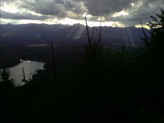 Right Inset: The dark skies barreling towards me.) I was hit with some brief periods of rain nearing the pass, and then some snow pellets as I headed over the saddle and down the backside towards Necklace Lakes. (
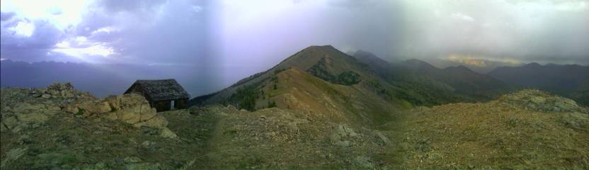 Inset: The view from the top of the saddle to the old cabin and Holland Peak.)
As I gaze up to the pass I crossed yesterday, I can see low clouds huddled over the peaks, and hear the wind howling above. The trail is full of wet overgrowth from last nights rain, which is dripping down my pants and filling my shoes with water. No, no matter what he manufacturer claims, nothing is ever fully waterproof in the backcountry. (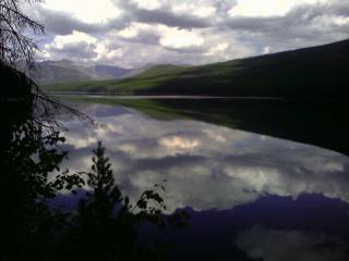 Inset: Big Salmon Lake.) As I walked along the side of Big Salmon Lake, the overcast skies slowly disappeared and the vegetation along the side of the trail started to dry out. I forded the South Fork of the Flathead River, where heavy horse traffic has turned the trail into a several inch deep dust bowl. Every step I take leaves a plume of dust. My shoes—now wet from the river crossing—are now covered in a concrete like mud. I finished my day above the river, and camped in a less than ideal location on the side of a hill. The faint sound of the rushing water below quietly rang in my ears as I drifted to sleep.
I continued my way down the S. Fork of the Flathead passing in and out of meadows and drainages, enjoying a few blueberries along the way. As I neared some thick vegetation, I heard a cracking sound off to my left, and saw a dark colored beast claw its way up a tree. The distinguished snout gave it away; I've spotted my second black bear on this trek. I backed off, and it crawled back down and ran away. Speaking of spotting a bear, I reached the Spotted Bear Ranger Station towards the end of the day and asked where I could get some water. The water sources shown on my map for the last several miles are all dry. The firefighters, from all over the country busy tending the several fires in the area, told me about the leftover food fridge. "If you don't eat it, it will go bad." one blurted out. I found myself enjoying a heaping plate full of chicken and stir fry vegetables. As I scarfed down the last of the food, I was invited to a pig roast down the road at the Wilderness Lodge. There was beer flowing, and three pigs on the rotisserie. Not bad, the nearest paved road is almost fifty miles from here. The evening was great, sharing stories between the twenty or so of us, and enjoying plenty of food and drink. There was quite the variety of people—the farmer who grows hops for Anheuser-Busch, the ones that deliver hay to all the ranches in the area,
the paying guests, the firefighters, and hiker trash—me.
I camped across the gravel road from the lodge near the river last night. The fire closure here near the Ranger Station has grown in size over the last few days from the strong winds and recent lightning. I'd like to find an open route through the Great Bear Wilderness, but I've come to a decision—I'm outta here. I hiked out to the main road around Hungry Horse Reservoir and wondered how many hours would pass by before I got a ride. Not more than fifteen minutes later, a car came by and picked me up. Nick, a guide at one of the outfitters up here, was headed into Whitefish for a few days and took me the fifty miles out to the highway on the hardened dirt road. I got another ride to Marias Pass, and I'm back on the CDT again. (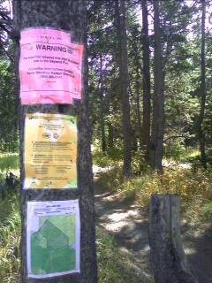 Right Inset: The southern boundary of the Bob Marshall Wilderness fire closure.) Seeing a CDT marker again brought a large sigh of relief. I'm past all the fire closures, and the detours are over.
Glacier National Park
As I left the rest area, crossed the highway and railroad tracks, and headed into the woods, I entered Glacier National Park. I stopped a short while later and sat down for a snack. My mind was clouded with thoughts. I wasn't out here for a weekend trek, not even a week long adventure. A month long epic traverse through an entire state? Nope, I've been out here for the entire summer. It's really starting to hit me now. All the planning and determination has paid off. I'm going to finish this #@$* thing. Unlike southbounders who finish in the middle of the desert, I get to finish in a spectacular location—and I'm gonna enjoy it. I'm in no hurry, and I'd actually like to take my time through here.
I know I'll be yearning for trail life when I return to the busy and touristy Vail Valley. I continued mainly through dense trees, with an occasional opportunity to see a peak. (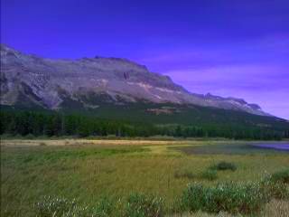 Right Inset: Three Bears Lake and the Continental Divide behind.) As I reached the town of East Glacier Park, I was stung by a wasp on the shoulder of the road and headed to the main strip.
East Glacier Park
After a shower at a hostel behind a restaurant—which removed the usual countless layers of dirt—and laundry, I saved time by putting my damp clothes on to dry them out. The dark sky was draped above me as I headed back into the main part of town and had dinner.
I walked across the street this morning to the small grocery for resupply and to pick up a package of water treatment drops I had sent here. The drops were supposed to arrive in Helena, and I forwarded this and my warm weather gear to Lincoln. In Lincoln, the drops were nowhere to be seen, and I had the Postmaster forward it again when it arrives. I called the company and they shipped another one out—this time express. Well, neither are here, and my supply has run out. Speaking of water treatment, East Glacier has a Boil Water Advisory. The town receives its water from a river with no treatment facility, and all the lodges and restaurants serve bottled water. Today's mail hasn't come in yet, and I'm hoping its on its way. I walked a couple blocks to the end of town to check at the Post Office—which is closed for lunch. Ok, I'll head next door to the gas station. I sat on my sleeping pad near the entrance with a pint of ice cream in hand. I plugged my PDA into the outlet behind me and made some calls. I phoned the Two Medicine Ranger Station and made my required itinerary through the Park—as of now, the 18th is my last day! I still had another fifteen minutes until the P.O. opened, so I grabbed another pint and started reading emails. When I'm not in range of a Wi-Fi signal, I can use my cellular signal to upload (update) my website and read emails. Since it's on a pay per use basis, I rarely use it. Uploading the text portion of my website—what you are reading right now—might cost $1 and the pictures $10 or $20. If you've seen this site with several empty boxes where a picture should be, this is why. I had a email from Jim (he and Mark started at the Mexican border the same day I did), trying to figure a route around the fire closures. As I sent off a response, I received an email from Mark this time—he'll be in town this evening. I stopped at the Post Office and walked out empty handed. Alright, is the Trading Post (they let hikers send packages there) going to have it yet? I walked in with my fingers crossed, and the woman behind the counter grew a bright smile on her face. This is looking good. She told me it came in on the truck today. What a relief. I had a small container of bleach with me I picked up from the motel I stayed at in Lincoln. It doesn't do much for giardia (unless I don't mind waiting several hours before I can drink the water) or other cysts, and I'm glad I didn't have to use it. I think I'm ready to go for a hike. I worked my way under the railroad tracks, through the other end of town, and back into the Park. This is my last opportunity on the trail to leave civilization behind, and I'm really going to enjoy it. The trail passed the usual grizzly bear warning signage at the trailhead and I soon worked my way up Bald Hill. ( Inset: Looking towards East Glacier Park from Bald Hill.) The Aquamira water treatment came in handy as I filled up my bottles from a creek near some old bear scat on the trail. I climbed my way up to Scenic Point, and the wind howled stronger with every step. I neared the top, occasionally needing to steady myself with my trekking poles. There was a short side trail to Scenic Point, but with the wind blowing me wildly about, I passed and worked my way down the steep switchbacks and eventually arrived at Two Medicine Campground. As I read the fee signage, $20 for a campsite, a car pulled up and I asked them where they were going. "East Glacier" replied one. You know what, I think I'm headed back into town! I guess my last opportunity on the trail to leave civilization behind starts tomorrow.
This time I tried the other hostel in town. The downstairs was the grocery, and upstairs was the hostel. There was a porch in front of the store on the second floor, and a long hallway following the length of the building. there was a bunk room, followed by a kitchen on one side of the hall and common area on the other. Further down were private rooms and then the shared bathrooms. With the in-house kitchen, I ate in tonight. Despite being late in the season, there were still several people staying here. A few decided to take the Amtrak Train from the big city and spend a few days to escape to the country. I checked my voicemail, and it was Mark—he and Janice are staying across the street! The two had taken a few days off, and will hike together through the Park. We got together for a few minutes and shared the usual stories. I liked theirs much better—the heated motel rooms, hot meals, malted beverages, and travel by car; the things we take for granted in everyday life. When they needed water, they just turned a handle. When I wanted water, I—Ugh. My stories involved mud, foot problems, sleeping in primitive conditions, and bad weather. I headed back across the street, smashed my head on the low beam above the door, and fell asleep (or passed out—one of the two).
I gazed out the window first thing this morning expecting to see cool, crisp blue skies as my eyes scanned the heavens. "Is there smoke in the air?" I asked myself. I rubbed my eyes and looked again. There was nothing but gray skies above. I packed up and headed across the street to meet Mark and Janice in their motel room. The weather was cold and overcast, with a light mist striking my face from a moderate breeze blowing about. After the three of us headed next store for some breakfast, we drove into Glacier NP and headed to the Two Medicine Campground Ranger Station. I sorted out my maps and adjusted my itinerary with the ranger. Instead of a near thirty mile day with a couple ten mile days, I'll traverse through the Park with around fifteen a day. Perfect—this is not a part of the trail I want to rush through. I put some long pants on (only the second time I've worn long pants since the South San Juans in Colorado) and a little after 11am, we were on the trail. We worked our way around Two Medicine Lake and up to Dawson Pass. The CDT officially heads over Pitamakan Pass, but has been closed for some time now due to bear activity. The wind gradually grew in intensity, and the clouds wrapped themselves all over us like a wet blanket. The first mile above treeline brought a stiff breeze that numbed my hands and chilled my bones. (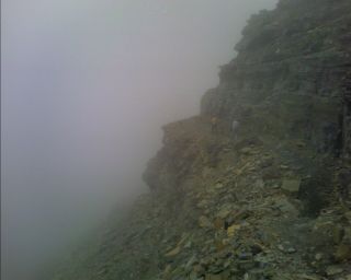 Inset:
On the edge, somewhere near Dawson Pass.) The trail eventually wrapped itself around to the leeward side of the ridge and the wind dropped to near zero. The fog is still thick, with a fine mist settling on everything. We stopped every now and then to admire the diversity of rocks we passed by. Mark—the forestry expert—showed us clumps of millions of algae petrified in the rocks from over a billion years ago. As we neared a saddle near Cut Bank Pass, the sun made a brief appearance as the clouds lifted for a few minutes, showing off the Nyack Valley and glaciers that lie in the small cirques tucked away on the steep slopes. As we descended towards our designated campsite at Morning Star Lake, we saw an owl fly away with a small bird grasped tightly in its claws, and listened to the frequent bugling of elk in the background. We set up camp, had dinner, and hung our food, while watching over a dozen mountain goats cling precariously to the steep cliffs above our camp.
Inset:
On the edge, somewhere near Dawson Pass.) The trail eventually wrapped itself around to the leeward side of the ridge and the wind dropped to near zero. The fog is still thick, with a fine mist settling on everything. We stopped every now and then to admire the diversity of rocks we passed by. Mark—the forestry expert—showed us clumps of millions of algae petrified in the rocks from over a billion years ago. As we neared a saddle near Cut Bank Pass, the sun made a brief appearance as the clouds lifted for a few minutes, showing off the Nyack Valley and glaciers that lie in the small cirques tucked away on the steep slopes. As we descended towards our designated campsite at Morning Star Lake, we saw an owl fly away with a small bird grasped tightly in its claws, and listened to the frequent bugling of elk in the background. We set up camp, had dinner, and hung our food, while watching over a dozen mountain goats cling precariously to the steep cliffs above our camp.
As the morning progressed, I climbed up to Triple Divide Pass under bright sun and cool September temperatures. (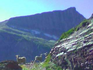 Inset: Bighorn Sheep near Triple Divide Pass.) Making my way to the top, I passed several bighorn sheep lazily grazing near the trail. To the south of the pass flows Atlantic Creek, to the west flows Pacific Creek, and to the north is Hudson Bay creek. Mark and Janice caught up to me towards the end of the day, and we continued to Red Eagle Lake. Their campsite was at the south end of the lake, and mine on the north. Trekking to the other end, I passed a moose feeding in the lake. Several minutes later, I reached my designated camp, where I met a crew of park employees out for the week planting over two thousand seedlings to replace those that burned in last years fires in the area. (
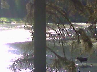 Right Inset: Moose in Red Eagle Lake.) As the sun slipped below the horizon and the night sky grew brighter, I could see Jupiter staring me right in the face off to the south. Other than the moon, it's the brightest object in the evening sky this month.
It was 25° this morning, a couple degrees colder than yesterday, but still quite comfortable for sleeping. I was on the trail by 9am, and down to shorts and T-shirt an hour later. As I stopped for breakfast, Mark and Janice passed by and we headed towards St. Mary Lake. Their campsite was supposed to be full of other people, but they had it to themselves. They saw two more moose, some bald eagles, and heard the hoot of several northern hawk owls nearby. As we headed along the shore of the lake, I saw my first bald eagle on the trail, and it was quite large in size as it gracefully flew by us. (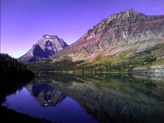 Inset: Looking across Saint Mary Lake to Going-to-the-Sun Mountain.)
I hiked ahead and took a side trail to Going-to-the-Sun-Road. The side trail was busy with tourists hiking to Virginia and Saint Mary Falls. One couple asked where I was coming from, and I replied with "Mexico". There was a long silence, and then they asked me again. I told them the story, and when we reached the road, they took me into Babb on their way to Many Glacier.
Inset: Looking across Saint Mary Lake to Going-to-the-Sun Mountain.)
I hiked ahead and took a side trail to Going-to-the-Sun-Road. The side trail was busy with tourists hiking to Virginia and Saint Mary Falls. One couple asked where I was coming from, and I replied with "Mexico". There was a long silence, and then they asked me again. I told them the story, and when we reached the road, they took me into Babb on their way to Many Glacier.
Babb / St. Mary
I picked up my maildrop at the Post Office, including my Passport I'll need at the Border. A local resident suggested I resupply at the larger grocery in St. Mary, and drove me there on his way home. I found an outlet in an unused checkout lane and waited four hours for my PDA to recharge. I picked up a little more than three days worth of food to get me to Waterton Park, Canada, and then bought some items I was able to throw in the microwave sitting in the corner of the store. The recharge light glowing on my PDA is still amber, so I went through the store again and purchased several more items. I used the microwave again and swallowed down a couple ice cream bars as I waited for another TV dinner to finish cooking. The store employees are from Romania, and were curious about my adventure. I talked with them for some time and then went over to my pack. I pulled my PDA out of the side pocket and noticed the green light—It's time to head out. The store only had a few customers, and they were all headed out of the Park—so I walked out to the road and threw out my thumb. Less than fifteen minutes later, a local resident out to take his young kids up to the top of Going-to-the-Sun-Road picked me up. They were going to watch sunset from Logan Pass, and took me back to the far side of St. Mary Lake. I reached the Reynolds Creek campsite and have the place to myself. After catching up on typing journals until 11pm, it's time to say goodnight.
I did the usual padding around the swollen area below my ankle and headed out. I headed towards Logan Pass instead of Many Glacier to avoid an almost twenty five mile day. My ankle isn't bothering me for the first time in weeks, and I don't want to screw it up with a twenty three miler. I feel like I'm on vacation—there's no rush, no need to get up early. If I want to stop every hour, I can. It feels great. I did the tourist thing at Logan Pass and went up to the visitor center. There were pictures on the wall showing what the glaciers looked like several decades ago. Now they're not much more than snowfields. They lack distinct crevasses, and don't move from the intense pressure above from the weight of new snow. Everything melts out quickly at the end of winter now, and come summer, the low elevation towns like Missoula swelter regularly in 90° heat. I filled my water bottles, headed out and was on the trail. There were great views of the valley below as I traversed the trail passing along the steep slopes. Smoke is in the distance slowly making its way up the valley. (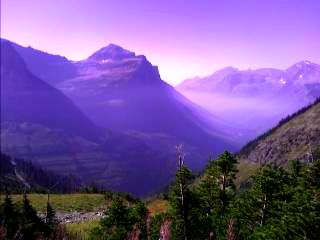 Right Inset:
The smoke on its way into the valley.) I took a side trail up to the top of the Garden Wall on the Continental Divide, which overlooks the Grinnel Glacier. (
Right Inset:
The smoke on its way into the valley.) I took a side trail up to the top of the Garden Wall on the Continental Divide, which overlooks the Grinnel Glacier. (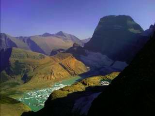 Inset: Mount Gould perched above the icy Grinnel Lake and Grinnel Glacier.) I made it to camp at Granite Park and met several other hikers. Two reported Team F-Yeah is crossing into Canada today, and Puff and Snappy were engaged as they crossed the Divide for the last time—and probably the youngest couple to earn their Triple Crown. The campground with its four tent sites was overbooked, so I'm sleeping under the stars nearby with a great view of the surrounding peaks and Milky Way.
I woke up to a white-grayish colored beast darting off into the trees. I wouldn't be surprised if it was a wolf looking for small rodents that hang around the food cooking area. Yes, there are special food preparation areas at all of the campsites. If one cooks where they camp, they could be wakened by a grizzly sniffing around their tentsite—or worse. All cooking and eating is done in a designated area, along with storing food in bearproof containers or hanging them from bear poles. When a bear associates food with people, it will become more aggressive against humans, and eventually killed if it attacks someone. I slept in to around 10am and was hiking again soon thereafter. The smoke is still in the air, shrouding the distant snow covered peaks with a monotone gray haze. The trail traverses around the side of the Continental Divide, with steep valleys off to my left, and lofty peaks to my right. Later in the day, the trail climbs up to a saddle ahead, and I cross the Continental Divide for the last time as I drop into the Waterton Valley. ( Inset: Over the Continental Divide for the last time.) I fondly remember the first time crossing the Divide back in the Coyote Hills in southern New Mexico. I dropped to the Fifty Mountain campsite and picked a site. There are developing clouds above, and I set up my tent as I first arrived. I headed to the food area and snacked on the usual gorp (trail mix), bag of snack mix, tortillas and cheese or tuna/salmon packets, ranch dressing, and beef sticks. I saw two more bodies arrive— Mark and Janice. They came in from Many Glacier after spending some time with family. The group of five from last night are also here, and as we're all making dinner, more visitors start to show up. They're not invited, and they are even starting to loiter around some people's gear. A while later there is a scream from Janice—"Jim, Jim!" He darts towards their camp and fights off the intruder that's running off with one of his trekking poles. More uninvited guests show up and start encircling our camp. One is eyeing our food area, another is over at the other camp sniffing around some backpacks, and a third is running off with someone's sweaty T-shirt draped over a tree branch. We start yelling at them, and eventually someone heads up to chase them away from our camps. The assailants are deer. The mule deer have grown accustomed to people, and will destroy gear or stand near someone urinating to lick the salts they contain. I headed back to my camp to see my tent still intact. The cloudy skies started to clear, and I got in my bag and typed up today's adventure.
The area was noisy with the stomping of deer in the area (we think they were just deer) during the night. There was some rain early this morning that splashed on my tent, and as I broke camp, I could see the high peaks shrouded in fog. The three of us broke camp, they had their hot drinks, I had my dry cereal, and we headed out. We climbed towards a small saddle, looking for any wildlife in the area. There were several dark colored rocks in the tundra, but none of them appeared to move. We approached the saddle, and I noticed one of the "rocks"
lazily lumbering around. I stopped in my tracks, and saw it move again. I could see a distinct hump on its back and the knew what it was right away. "Grizzly!" I yelled out to the other two. We all looked over to the dark colored grizzly bear two hundred yards from us. It was foraging for food, slowly working its way away from us. It walked over the end of the meadow
and disappeared. On our last day on the CDT, we finally saw our first grizzly on the trail—finishing the CDT without a griz sighting wouldn't have been the same. We hiked on, with smiles on our faces, and headed over a small saddle. I saw Mark stop in his tracks and he pointed to two
 objects. Two more
grizzlies! It was a cinnamon colored sow and her cub, darting away as they spotted us. Ok, that makes three grizzlies in less than five minutes.
Neither of us saw that many black bears on the entire trail! We began the long drop into the Waterton Valley, passing over log bridges and crossing dry creekbeds.
After a few miles, we reached the Goat Haunt Ranger Station. We took a break under the pavilion watching the tour boat dock nearby,
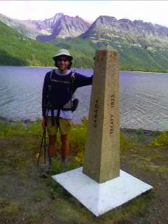
and dark clouds hanging over the high peaks all around us. As we headed around Waterton Lake, a feeling of quiet exultation completely enveloped my mind. The border is just ahead. My eyes grew wider, and I could feel the end of the trail grow closer. I spotted Street Point across the lake and knew we were less than a mile from the end of the trail. My pace had
picked up, and I could feel my heart thumping. Up ahead I could see a monument; one metal, and an older stone one. We stopped, had Janice head on to take some photos, and headed across the finish line. Wow, this is it. After twenty five hundred miles, I was done—done with the rain, done with the fire closures, done with the routefinding. No more twenty to thirty mile days, no more worrying about where to find water, or wondering how I'm going to resupply from some
in-the-middle-of-nowhere gas station convenience store. I don't really have any words to describe how I feel right now. (Inset: Canada.)
objects. Two more
grizzlies! It was a cinnamon colored sow and her cub, darting away as they spotted us. Ok, that makes three grizzlies in less than five minutes.
Neither of us saw that many black bears on the entire trail! We began the long drop into the Waterton Valley, passing over log bridges and crossing dry creekbeds.
After a few miles, we reached the Goat Haunt Ranger Station. We took a break under the pavilion watching the tour boat dock nearby,
and dark clouds hanging over the high peaks all around us. As we headed around Waterton Lake, a feeling of quiet exultation completely enveloped my mind. The border is just ahead. My eyes grew wider, and I could feel the end of the trail grow closer. I spotted Street Point across the lake and knew we were less than a mile from the end of the trail. My pace had
picked up, and I could feel my heart thumping. Up ahead I could see a monument; one metal, and an older stone one. We stopped, had Janice head on to take some photos, and headed across the finish line. Wow, this is it. After twenty five hundred miles, I was done—done with the rain, done with the fire closures, done with the routefinding. No more twenty to thirty mile days, no more worrying about where to find water, or wondering how I'm going to resupply from some
in-the-middle-of-nowhere gas station convenience store. I don't really have any words to describe how I feel right now. (Inset: Canada.)
September 17, 2007

Continue to