Pie Town
Ok, so this is Pie Town! A small hamlet of about 50 people, consisting of run down homes with new trucks in the driveway, a small church, dilapidated community center, and park. The sixteen mile roadwalk was brutal, and I know it messed up my feet, but it feels great to be here. The monsoons are in full effect. A brief downpour woke me up this morning at 6am, and now there are black clouds encircling me again. It's raining every afternoon now—something that typically doesn't happen until July. I walk through town to the highway and into the Pie-O-Neer Cafe. I'm greeted by owners Kathy and Stan, busy serving the lunch crowd of passing tourists. In the corner sitting at a booth are four thru-hikers, Puff, Snappy, Crazy Horse, who I haven't seen since the Gila River, and Apteryx—a thru-hiker from New Zealand. I join them and immediately order a chiliburger with everything on it, a pile of coleslaw, slice of pie, and a large milk with chocolate sauce and ice cream (the milkshake machine is down, and I don't drink soda). (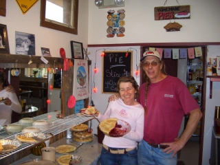 Left Inset: The Pie-O-Neer Cafe owners Kathy and Stan.) The storms hit with a vengeance, and the lights start to flicker. We laugh off the weather, and the other three talk about their adventures on the PCT (Pacific Crest Trail thruhike) last summer. I order up another gigantic plate of food, and we all call it good at 5pm. Kathy invited is to stay past closing time and use the shower in the back. Thru-hikers are definitely a colorful group of people. We come from all backgrounds, all walks of life, and every personality imaginable. Most have done the Appalachian Trail straight out of college (like I did), after a job layoff, between careers, or after a divorce. You name it, there's about as many reasons for doing a thru-hike as there are thru-hikers. A lot of locals like to hear these stories we share with them. Why have we hiked thousands of miles to get here? As the evening progressed, we headed over to Nita and Don's old house in town. They are the Pie Town Trail Angels—they invite CDT hikers into their home for meals, showers, and laundry. They recently moved several miles out of town, and were in California at the time, but insist "their porch is for the hikers". As I punch up my journals on this tiny keyboard, Crazy(Horse) is jamming away on his guitar, and Puff and Snappy are lounging away on the old seats next to the picnic table salvaged from a car. There is an occasional crack of thunder, and the light pitter-patter of rain falling as we relax on the covered porch, adding or removing food items from the hiker box as we rifled through our maildrops retrieved from the post office earlier today.
The next couple days were mostly the same. Crazy, Puff, Snappy and I encountered nothing but roadwalks, roadwalks, and more roadwalks, sometimes passing numerous subdivisions filled with empty lots miles from nowhere. Most land in the area is private, and getting the trail off the road will take many more years of planning. The Continental Divide Trail Alliance held a meeting at the Pie-O-Neer last year to pull together the local ranchers and address this issue. Most were in favor of allowing hikers across their land, but as time passes by, more and more land becomes subdivided and sold off in lots. So many challenges remain. For right now, the roadwalks are the only option.
As we neared Grants, I took the Rim Trail, which climbs above the highway and brings The Malpais into view, a vast expanse of lava that belched out of the earth eons ago. (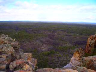 Inset: The Malpais lava flow.) As I passed around the corner, I was at the La Ventana arch, the second largest arch in the state. It was a welcome sight after the repetitiveness of the terrain we have passed the last several days. I met up with the other three back at the paved highway, and we started our trek across the Zuni-Ancoma Trail, which follows the ancient Indian routes used to reach different villages across the lava flows. This was some of the most challenging terrain we have passed yet. The trail is nothing more than a cairn every hundred feet or so, passing over, around, and through large jumbles of sharp, pointy lava that undulates through the area, dotted with vegetation and small trees. We weren't traveling anything more than a mile an hour, struggling through the challenging, rocky terrain. Several hours later, we made the seven mile trek through the lava fields. We grabbed water from a cache the other three left on their drive down to the Mexican border last month. A local was stopped in the area with his wife, shooting away at ground squirrels in the area. He picked up the empty can he threw out the window as we approached, and we introduced ourselves. He offered us a beer—my first beer I've had since I started—and even some elk jerky. As the thunder off in the distance got louder, we thanked them, and we were on our way. As the night sky continued to drape its dark curtain over us, we continued our trek into the night. Bright strokes of lightning ignited the horizon in white, briefly showing us what lie ahead on the road up Bonita canyon. Another storm was developing to our left as we trekked on. The thunder roared louder, as the lightning grew more intense. We all stopped at the same time and wondered if it was a good time to build camp. Instead we headed on, doing miles tonight to make the hike into Grants a little easier. As we continued on, the skies became furious. It started pouring on us, and we headed off the dirt road and set up camp in the intense storm. Lightning was everywhere, and the thunder was deafening. As we crawled into our tents ten or twenty minutes later, the thunder echoed off in the distance, and the rain stopped its intense assault on us.
The next day we were up bright and early for the long hike into town. We hiked out of Bonita Canyon and into Zuni Canyon and took a break. Our soaked tents were thrown everywhere (known in the backpacking world as a "yard sale") to dry as we rested under a tree and heard the dull roar of thunder in the distance. Our tired bodies were ready for a town stop. Our feet were sore from walking on lava, pavement, and gravel since Pie Town. It was going to be nice to see the rain out of a window instead of on top of us, and we continued our rapid pace towards town.
Grants
As we walk into Grants and cross over Interstate 40, we are greeted with two fast food restaurants. We gorged at the local KFC, and I dropped thirteen bucks on my lunch. We stumbled out a while later and began the long trek through town to find a place to stay for the night. We stopped at a liquor store to pick up some supplies to celebrate the birthdays of Snappy and I, and look for a motel. As we trek through Grants, we can see The Narrows off in the distance, where La Ventana Arch is, not more than a twenty minute drive away. (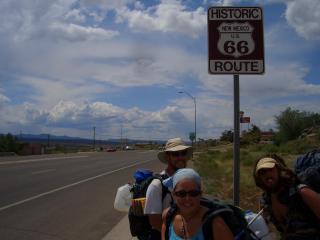 Inset: Getting our kicks on Route 66.)
We reach our home for the next two nights, which happens to be on "Route 66", order pizza, and call it a night at 1am.
Inset: Getting our kicks on Route 66.)
We reach our home for the next two nights, which happens to be on "Route 66", order pizza, and call it a night at 1am.
As I write this today, I'm in a local Chinese restaurant enjoying their all-you-can-eat buffet. I've been here for two hours, and I'm on my third huge helping of food. It feels good.
This morning we were all up bright and early for the hike over Mt. Taylor. I stuck around town for a while longer so I could down a footlong sub for lunch. The CDT follows the highway out of town, and I took cover under the facade of a commercial building during a brief thundershower. It winds its way up past some housing developments, passes a state prison, and eventually leaves the road to climb onto the Horace Mesa. As dusk approached, I was eyeing Mount Taylor, which was towering over me with low clouds dancing around the summit. As I left a jeep road for the climb to Mt. Taylor, I saw Puff, Snappy, and Crazy Horse setting up camp, and stopped for the day. Our camp was surrounded by towering aspens, another new sight on the trail.
The 4500 foot climb up Mt Taylor (11,301ft) is the biggest so far (yeah, there will be a few more climbs to Canada). Small pockets of snow rest in the gullies, some on the leeward slopes, and one to three feet rest in the trees on the trail. After stopping for lunch just past the summit sheltered from the wind, I saw a hiker through the trees. "Is that Cheers?" I cried out. "Yes, that you Skygod?" We met briefly in the Wal-Mart parking lot as I came out with my new cushioning insoles, parachute cord, Moleskin, socks, and of course food. We originally met at the
Rockies Ruck, a gathering at the Leadville, CO Hostel the last weekend in February. There's typically twenty or so there for the weekend. We watched videos taken by past thru hikers, shared wild stories of life on the trail, and spent most of Saturday ski touring around Tennessee Pass.
I rose this morning to the gobble-gobble of a nearby wild turkey, and by 6:30 Cheers and I were on our way. Not more than an hour later, we saw Crazy Horse, Puff, Snappy, and Greyhound walking out to the dirt road starting their day. It was hiker reunion of sorts, with everyone but me sharing talk of their thru-hike of the Pacific Crest Trail (PCT) in the last year or two. Boy, did they have stories! If it wasn't about the colorful personalities of other thru-hikers, it was the challenging weather, or difficult terrain that greeted them. (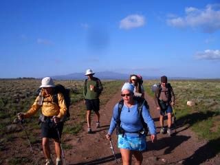 Inset: The clan, with Mt. Taylor in the background.) After filling up our water bottles at the spring in Los Indios Canyon for the next dry fifteen miles, we left the road for a cairned cross country route. We all ranted and raved about how special it was to finally be on a faint trail again instead of the foot mashing monotonous roadwalks. We worked our way across the viewless treed mesa for most of the day, and eventually came to the edge of the rim. We stared in awe as we looked at the endless horizon and valley floor dotted with spires and canyon rims painted every color of the rainbow across the landscape. We reached the valley floor a while later, and spent the night near the Ojo Frio Spring after the twenty-nine mile day. (
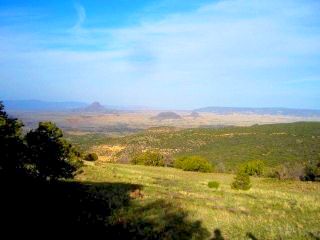 Right inset: Now this is what I envision of when I think New Mexico.)
Cheers, Greyhound, and I were on the trail a little after 6am to reach the next good water source—water that wasn't green, brown, or orange—almost thirty miles away. Our trek took us along the top of mesas hugging the edge of their jagged rims, perched high above the valley floor. We were treated to jaw dropping views of the surrounding terrain this morning as the sun often poked through the cloudy skies, beaming its brilliant rays onto a lone spire. The distant edges of mesas would glow as if they were fired from within. (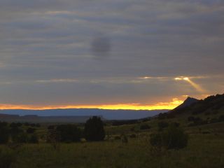 Inset: Watching sunrise behind Cerro del Ojo Frio.)
We hiked from mesa to mesa today, slowly working our way north as the sky darkened above us. An occasional rumble of thunder or intense splash of rain would accompany us as we walked along the edge of the mesa rims. In what seemed like the middle of nowhere, we crossed a paved road and an oil pipeline that may feed much of Colorado its gasoline. We finished our day near Jones Canyon Spring, with a pipe trickling water into an old, rusty trough firmly seated in the sandy ground.
We trekked off the mesa this morning, and followed the paved highway into Cuba. Other than a moderate breeze and temperatures in the low 70s, there were no storm clouds brewing overhead, and thoughts of a shower, food, and rest were setting in to ease our minds.
Cuba
After arriving in town midday, we stopped for a bite to eat, checked into a motel room, and headed over to the library next door to use the Internet. We ran into Apteryx at the motel (who I last saw in Pie Town) and all headed over for dinner at Bruno's, where each of us ordered a healthy helping of fajitas, surrounded by plenty of salsa and tortillas.
As I make a few phone calls and type up my journals for the last several days in the comfort of our three bed kitchenette motel room (no, the kitchenette doesn't have any dishware, if we try to light the ancient stove we'll probably blow ourselves up, and no, and the whole motel room vibrates when the cold water tap is turned on). I can hear Cheers and Greyhound in the next room sharing their fantastic stories about the PCT—hiking through godforsaken desert heat in southern California, and slogging through record snow in the Sierras. They're also trying to figure out what to do and where to go tomorrow. Just north of here, the trail climbs the Colorado Plateau and stays at higher elevations, and there are reports from a couple hikers ahead of snow on the ground above ten thousand feet in many places. Granted, that was two weeks or so ago, but I contacted some friends around Colorado and heard about the 6-12 inches of new snow that's fallen while the temperatures have dipped into the low 20s at night.
The trail several days ahead is buried in snow, giving me another reason to slow down and let it melt. I've been sucked into big days traveling with other hikers trying to finish the trail by midsummer, and to a certain extent, it feels great! Since starting, I've been telling myself I shouldn't do anything more than twenty miles a day through NM—snow lies on the trail ahead, it might not be good for my feet that aren't trail hardened yet, etc, etc. Well, now I know I can do it. I can do the miles necessary to finish the trail by early September or earlier. What it will be like going from the flat terrain of New Mexico to the constant up and downs of Colorado—I don't know, but I'm not too worried. On the other hand, the twenty five to thirty mile days I've done recently are starting to wear on me. Not so much physically, but more mentally. This kind of mileage requires getting up at 6am, hiking at a consistent healthy pace, taking only a few brief stops, and continuing on until the sun is dropping behind the horizon. Very little time is left for journaling, no time for reading or any other leisure activity, and very little is left to just stop at an overlook and take in the sights and sounds of my surroundings. But this is thru-hiking, and every thru-hiker has different reasons for doing it. Some enjoy a fast, steady pace, and get bored at the thought of taking long breaks or getting into camp when the rays of sunlight are still striking the ground. The saying out here is "hike your own hike." Why am I doing this hike? I'm not trying to get my Triple Crown (yet, at least) which consists of completing the AT, PCT, and CDT; nor am I trying to prove anything or set any records. I just enjoy backpacking, and the simplistic lifestyle that comes with it. It feels good to release myself from the burdens and distractions of society, and to leave the incessant industrial noise that follows us everywhere we go behind. Sometimes I feel like something essential inside us has died—that desire for quiet and solitude that has slowly disappeared from our mind and souls. I don't want to be a completely civilized person with dulled senses from the fast pace of the modern lifestyle. Out here, I have regained those basic senses, and live them every day.
My feet are in great shape, except for the fact that my bunion and bunionette on my left foot are rubbing against the side of my shoe. The Montrail Hardrock trail running shoe is a size big. As one's foot slams against the ground for five hundred miles, it swells and expands. Maybe a half size, or sometimes three times that. The shoe is also a wide. I knew these bone spurs born from wearing plastic shelled ski boots for most of my life would likely bother me, so I wanted something a little wider. Apparently it's not wide enough behind the toes. As much as I'd like to use a knife and cut out the problem spot on the shoe, there's critical stitching in that area, so I'll try cutting away the sock instead.
The next morning, Greyhound left around 7am, and Cheers and I took a Zero Day (a day off). Cheers headed over to the Post Office to pick up a pair of new shoes he bought awhile back. Every evening he has to reglue the delaminating sole that is starting to flop around as he walks. In addition, there's a structural collapse in the heel—every time he takes a step, he rolls his ankle. When he returned from the P.O. I could see look of anger and frustration in his deeply creased face. "They're not there" he angrily grunted. On the way back through town, he came across a small UPS package facility. He taped a note on the door if for some reason it was sent accidentally via UPS. He called a retailer and ordered another pair, before the shoes turn into a pair of soleless, open air slippers. "I guess I'll need to deal with these for a while longer" he blurted out with a sigh on his face. About an hour later, there is a knock on the door. Are some other hikers in town looking for us? Cheers opens the door. The solemn look on his face suddenly disappeared as the UPS driver hands him his new shoes. This was completely unexpected! When a package is sent via General Delivery, it can only be picked up at a Post Office. If it's sent FedEx or UPS, it is generally returned to the sender. Apparently, the person taking his order over the phone weeks ago has never dealt with a thru-hiker before. I headed out and resupplied at the grocery store nearby, while stormy, black clouds swirled around above me. The music coming from the scratchy sound system was interrupted several times by the Emergency Broadcast System, warning of nickel size hail, flooding, and heavy rains in the area. What a great day to take off! As I write this, I'm on my fifth bowl of chicken, vegetables, and fried rice I picked up at the grocery, with one to go, a gallon of juice, a few bananas, and a pint of ice cream waiting for me in the mini fridge. I'm also in the initial stage of a food hangover.
Cheers and I left the motel at 11am, and were greeted by friendly skies today. He stopped for a fast food lunch, and as usual, I left town with way too much food. I started snacking on chips on the way out of town and began the gentle climb up into the San Pedro Parks Wilderness. Other than the upper reaches of Mt. Taylor, I haven't seen any terrain like this. There is water everywhere. At 9,000ft there is snow piled around like scattered puzzle pieces. I met up with Snappy, Puff, and Crazy Horse, and found out they decided to stay at a motel—the same one we were at—after the parking lot turned into a lake at the fast food joint they were eating at yesterday. The trees above 10,000ft held plenty of snow we had to slog through, and the large meadows were teeming with water—and we crossed several of them as our shoes helplessly filled with water. (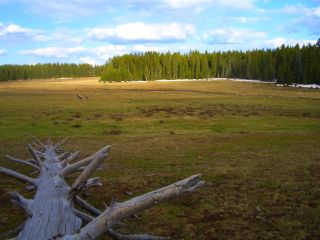 Inset: The meadows in the San Pedro Parks Wilderness.) Not wanting to hike twenty miles, I stopped around 6pm at San Pedro Peak and made camp at 10,600ft.
As I descended from my camp to the valley floor today, I could hear the familiar distant roar of thunder at 10am. (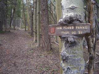 Right Inset: An aspen tree growing around the trail sign.) I passed a couple new trails constructed recently, or not constructed at all. As I walked along a dirt road near the highway, I saw a post on either side of the road. I got closer and saw a CDT logo nicely etched into the four foot high round wooden post. Great, I'll follow this new tread. About a mile further, the tread slowly disappeared, but there was survey tape continuing to mark the trail. As I approached a fenceline, the survey tape disappeared. Ok, if for some reason I go too far left, I'll reach the highway; too far right and I'll meet the dirt road I recently diverged from. After following a compass bearing through Cañon Ojo, I started to see survey tape again, crossing over recently cut trees, and through a maze of brush. Is this survey tape even trail related? Why would there be CDT posts near a road if the trail hasn't even been built yet? Oh well, it's taking me in the right direction. The overgrowth and brush closed in even tighter as I continued on. It repeatedly grabbed my pack, smacked me upside the head several times, and stopped me in may tracks all too often. As I wrestled my way through, I eventually found a jeep track and followed it out to some powerlines. I continued out along the dirt road to the highway, only to notice a trail of UV degraded survey tapes coming out of the brush and terminating at the paved highway. I traveled a mile down the road to get some water at the USFS Ranger District offices that were closed, and hiked back to the jeep track that took me up to Camino Mesa. My map shows more roadwalking, but during my planning, I found a supposedly new trail I scribbled on the map. Sure enough, there's that CDT post marking the new trail. I started up the new trail, and less than a hundred yards later, it disappeared. There are blackened tree trunks everywhere in here. The forest fires do their jobs well. I'm less than a hundred miles from Colorado, and I have yet to see acre after acre of dead, blackened trees from years of fire suppression. Instead of dead trees, I see blackened trunks. There's only a small amount of undergrowth that never has a chance to grow to the thick and dense consistency needed to create the fires hot enough to kill everything in their path. Seeing the mesa clearly on my map, I climbed to the top anyways. I saw a hint of a rainbow glowing in some virga across the next canyon as I continued along the jeep road. Although only half the length of what I drew on my map, I saw a CDT post and cairn taking me off the road. I followed the trail off the side of the mesa only to have it fade away in some deadfall. It amazes me how little hiker traffic most of the trails around here actually receive. It seems most locals are either throwing their beer can out the car window, or shooting up road signs or ground squirrels from their ATV. Anyways, I found the trail a little while later, and followed it down to the road I left a while back. The adjacent meadow was green and the aspens were full of half dead trunks, which I don't see very often, probably from years of drought.
I descended to the bottom of the canyon this morning and continued on through the trees and eventually into open terrain. I look around at the mesas that tower above me, with their cliff walls a multicolored mosaic—thanks to sitting at the bottom of the sea for millions of years before being thrust straight up thousands of feet eons ago. I feel like I'm standing at the bottom of an empty swimming pool, with its walls standing sentinel above me. I reach the Chama River and cross an old bridge to a dirt road, busy with rafters doing car shuttles for this stretch of river. As I gaze down at the swirling waters, several rafts pass by, tossing their occupants around like an amusement ride. I'm sure the water is running a little higher than usual with the monsoonal flow over a month early this year. (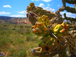 Inset: the flowering Walkingstick Cholla plant.) Although it's not even 3pm, I'm done for the day. I climbed a hill near the highway and sat there, with my 360° views and a steady breeze blowing gently across the landscape. I read the torn out pages of a book I had mailed to myself back in Pie Town. I figured it was time to read it and do away with its dead weight I've carried with me for this long. I don't do much reading, and figured I could do a little on the trail when time permits—and this is the first time I've had that chance. From now to Chama, I'm going to stop a little more often, make camp a bit earlier in the day, and just relax. There's a little voice inside my head that's telling me the Weminuche in Colorado is teeming with snow. I could have my nordic gear mailed to me and ski tour the range, but I don't think I'd get very far each day, and I'd likely have a fresh set of blisters and hot spots to contend with. As I type away tonight, I see the almost full moon shining its brilliant white glow on the mesas all around me. On either side of the moon, I see Jupiter, Venus, Saturn, and Mercury making their trek through the night sky.
After crossing the highway, I stopped at the old Forest Service Visitor Center now run by Ghost Ranch looking for some water. Miles poked his head out and told me they weren't open yet, but offered me some water. After a lazy couple miles into Ghost Ranch, I told myself I'm going to take the rest of the day off. Maybe even part of tomorrow. Why not?
Ghost Ranch
This morning I hiked what's called a "Nero". It was just about three miles into the Ranch. Not exactly a zero mile take-the-whole-day-off day, but instead it was one of those days where I wanted to arrive early and give the body plenty of rest. So this is the place I've heard about for so long. It's a retreat run by the Presbyterian Church, and currently has several different groups staying here. There's a group of high schoolers over at the campground, there's large group of two hundred people that are followers of Lynn Andrews, who wrote the book Medicine Woman as her first project. Cheers departed this morning, and Puff, Snappy, and Crazy Horse will be leaving soon. I went into the office to pay for a campsite, took a shower, and emptied my bag of athletic smelling clothing into the washer. There is a computer lab on the premises too, so I ordered a new pair of sunglasses, some socks, and a new pair of shoes for the trail ahead. It feels good to engage in activity that doesn't involve intense physical exertion for a change. I went to the cafeteria for dinner and met up with Miles and the campground host Melissa I met at the office. They wondered If I was actually going to finish the massive, heaping mound of peas and chicken I had so carefully arranged on my plate. Forty five minutes later, I went up for a second very generous helping of their vegetarian plate they were about to toss out as the kitchen closed. I can barely move.
I stopped by the computer lab again to reorganize my website, add some pictures, check the order status of my recently purchased trail goods, and look for the usual email replies. As darkness approached, I headed over to the campground and joined Miles, Melissa, and Bob, the Ranch's Registered Nurse. We sat around the campfire and shared stories. Most of them have only been working here for a month or so, but were still able to name some colorful figures who have worked here in the past, or thru-hikers that have passed by. As the almost full moon continued to work its way through the sky, we extinguished the fire and said our goodbyes.
I stuck around until the heat of the day had passed—if the 70s is considered hot—and picked up my maildrop. I stuffed the new food items into my pack, and enjoyed one last meal at the cafeteria with Hawkeye along with Rusted Root, who I briefly met in Grants. He hiked in today, and was planning on taking the rest of the day off. He's the only one I've met that also thru-hiked the Appalachian Trail in 1997. A little while before leaving, I looked at my map of the trail ahead, with all its detail scrunched onto an 8.5x11 sheet of paper. "Ok, so how do I get out of here?" I asked myself. Do I just bushwack down to the arroyo and head northeast up the next canyon? I asked some employees of they knew where the CDT headed from here as they left the cafeteria after dinner. Not a single one had the slightest clue. It's seldom traveled around here, and thru-hikers are few and far between. Great, now these people are probably wondering how someone can make it here six hundred miles from the Mexican border, but can't find a trail that goes right by the Ranch. I knew should have gone with my original plan—get out my map and compass, and just bushwack my way into the right canyon. I headed down a walkway looking for a trail that headed to the arroyo and found nothing. I turned around and did the same thing. The closest thing I found was an adventure course the ranch runs for team building exercises. I followed it down to the barely flowing creek and traveled upstream. I saw another arroyo full of cottonwood trees and headed over. This is a trail all right, which goes up to the Kitchen Mesa the locals were talking about. I followed the Box Canyon trail about a mile or so until the trail faded into a barely discernable tread. (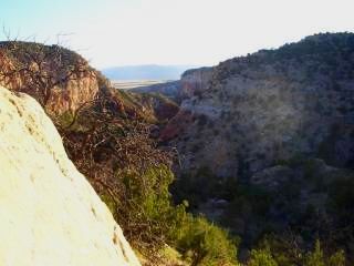 Inset: Above Ghost Ranch.) Beyond, I followed an old jeep track in places, and in others, I just followed my compass bearing. It started out with a moderate climb out of the arroyo, with the evening sun casting a brilliant glow onto the canyon walls. I followed the trail through juniper forest, and continued climbing until I reached pine forests that lie below the towering mesas above. As much as I wanted to hike under the full moon, I'd probably end up following some cattle trail or old jeep track in the area. I didn't feel like spending all day Thursday trying to backtrack and figure out where I am, so goodnight.
Yes, sure enough I followed a cattle trail at dusk. I bushwacked my way up to
the top of the mesa and headed east until I reached the dirt road. When the
trail did leave the road, it usually disappeared into the meadows from all the
spring rains. It's really lush up here, and even some of the roads are difficult
to spot in places. With the abundance of moisture comes another issue—bugs. While not bad, in some areas sheltered by the trees, the no-see-ums were silently buzzing around my face, and of course in the ears. For some reason, bugs love flying around our ears. The snow clings in some areas on the leeward slopes of Mogote Ridge, and the vast openness of the high elevation rolling terrain is another new sight on the CDT. I have seen smoke rising from a forest fire off to the southwest for the last two days—probably not doing any better from the strong winds that have pummeled the area today.(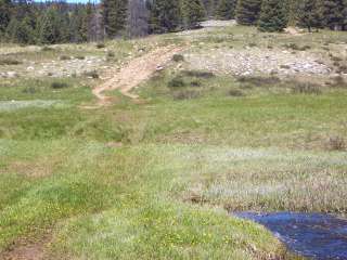 Inset: Where
does the road go?)
Inset: Where
does the road go?)
I traveled cross country to the road above me and, well I guess you could say I did that quite a bit of that today. Many of the roads the trail crosses were closed many years ago. Most still have illegal ATV tracks on them, but the wet spring has cast a green, grassy curtain across most in places. My map has almost disintegrated from constantly pulling it out of my pocket to take a compass bearing every now and then. Do I take that right turn here, or in another hundred feet? Where's the road that's supposed to veer off to the left of Fifteen Springs? Is this the meadow I take to reach the Rio Vallecitos, or is there another one lurking just ahead? I followed the steep descent down to the Vallecitos River and was surprised by the surrounding beauty and size of the river. At a glance, the map looks like a 1:60000 scale, due to the fact it was shrunk down to fit on an ordinary sheet of paper. It makes the river look like any other creek. The trail dead ends on a road that is gated at a private ranch. I follow the animal trail that hugs the fenceline only a few inches away in places with a weary eye. As I enter a dense area of trees, my vision is impaired—as if I've had bright lights shoved in front of me and suddenly removed. Then it happened. My arm brushed up against the barbed wire fence, and I felt like someone had grabbed me as the barb stabbed me in the arm. I pulled out the first aid kit, patched up a hole, and went back on my merrily way. I swatted at the masses of mosquitoes that were swarming around me for the first time climbing up Placer creek, and as I reached the top of a cliff towering above me, I set up camp as I listened to the gurgle of the water echoing into a deep rumble playing all around me, bouncing off the vertical canyon walls that surround me. (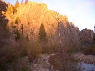 Inset: The cliffs bathed in alpenglow at the bottom of Placer Creek.)
I had Rusted Root hike by me as I was stuffing my sleeping bag into my pack this morning. Whe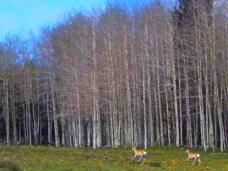 n not hiking, he's designing clean rooms or some other sort of specialized facility as a construction manager for companies such as Intel, IBM, and Lucent. A little ways up the road, I saw ATVs buzzing around the meadows. I saw campers with the usual portable kitchen supplies, barking dogs, tents large enough to do jumping jacks in (sometimes I really wish I had one of those), and generator operated water pumps. Water pumps? What are they doing out here? Apparently today is the start of the prospecting season. They are panning for gold out here, sifting through the various sediments hoping to make a few dollars. (Right Inset:
Pronghorn that have just spotted me.)
n not hiking, he's designing clean rooms or some other sort of specialized facility as a construction manager for companies such as Intel, IBM, and Lucent. A little ways up the road, I saw ATVs buzzing around the meadows. I saw campers with the usual portable kitchen supplies, barking dogs, tents large enough to do jumping jacks in (sometimes I really wish I had one of those), and generator operated water pumps. Water pumps? What are they doing out here? Apparently today is the start of the prospecting season. They are panning for gold out here, sifting through the various sediments hoping to make a few dollars. (Right Inset:
Pronghorn that have just spotted me.)
As I type this up camped atop Brazos Ridge tonight, I can see the skyglow from Santa Fe to my south, the twinkling lights from probably Alamosa, CO to my north, some lightning erupting the sky red far off to my east and north, and the usual shooting star or two overhead. (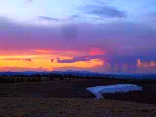 Right Inset: Sunset from Brazos Ridge.)
This morning as I desce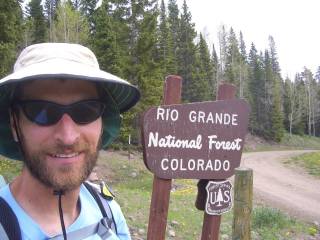 nded the winding dirt road, I looked at my map and saw the dotted line going across the map. It was the New Mexico / Colorado border. As I approached, I saw the sign for the Rio
Grande National Forest, and crossed a cattle guard marking the border. (Inset: Welcome to Colorado.)
Wow, so that was New Mexico. What an amazing state. The diversity I saw over the last month was incredible; the deserts, the high mesas, lush meadows, high peaks. I feel like I've seen it all. Rusted Root caught up with me as I took a break at the state border with the last six hundred miles of trail experiences running through my mind. I had the first required hitchhike to get to a town today. In New Mexico, we walked into all the towns. Now we hike across the high ridges and to the top of the mountain passes, requiring a hitch into town. We were picked up in a light rain, as Puff and Snappy were dropped off to continue their way north.
nded the winding dirt road, I looked at my map and saw the dotted line going across the map. It was the New Mexico / Colorado border. As I approached, I saw the sign for the Rio
Grande National Forest, and crossed a cattle guard marking the border. (Inset: Welcome to Colorado.)
Wow, so that was New Mexico. What an amazing state. The diversity I saw over the last month was incredible; the deserts, the high mesas, lush meadows, high peaks. I feel like I've seen it all. Rusted Root caught up with me as I took a break at the state border with the last six hundred miles of trail experiences running through my mind. I had the first required hitchhike to get to a town today. In New Mexico, we walked into all the towns. Now we hike across the high ridges and to the top of the mountain passes, requiring a hitch into town. We were picked up in a light rain, as Puff and Snappy were dropped off to continue their way north.
Chama
After checking out a few hotels in the old part of town, Rusted Root and I scored the last room at the Chama Station Inn. The place is full of tourists riding the main attraction in town—the Cumbres & Toltec Scenic Railroad.
(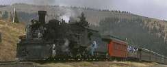 Inset: The Cumbres & Toltec.)
Continue to Southern
Colorado